


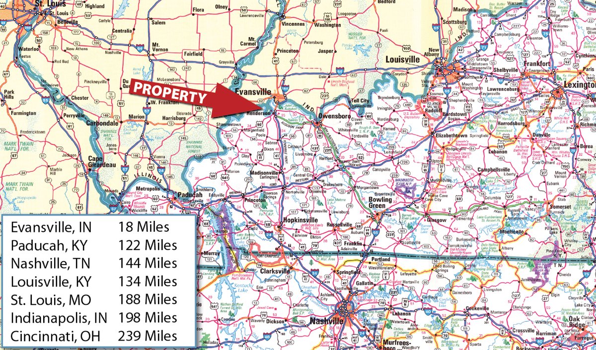
• 3,435 +/- Acres of Productive Tillable Land • Excellent Grain Markets/3 Miles to River Terminal • Over 2 Miles of Ohio RIver Frontage • Prime Hunting along the Mississippi Flyway • Adjacent to 10,000 Acre Sloughs Wildlife Management Area • Excellent Recreational Opportunities • Tracts Ranging from 2+/- Acres to 350+/- Acres • 7+/- Miles to Henderson, KY • 20+/- Miles from Evansville, IN
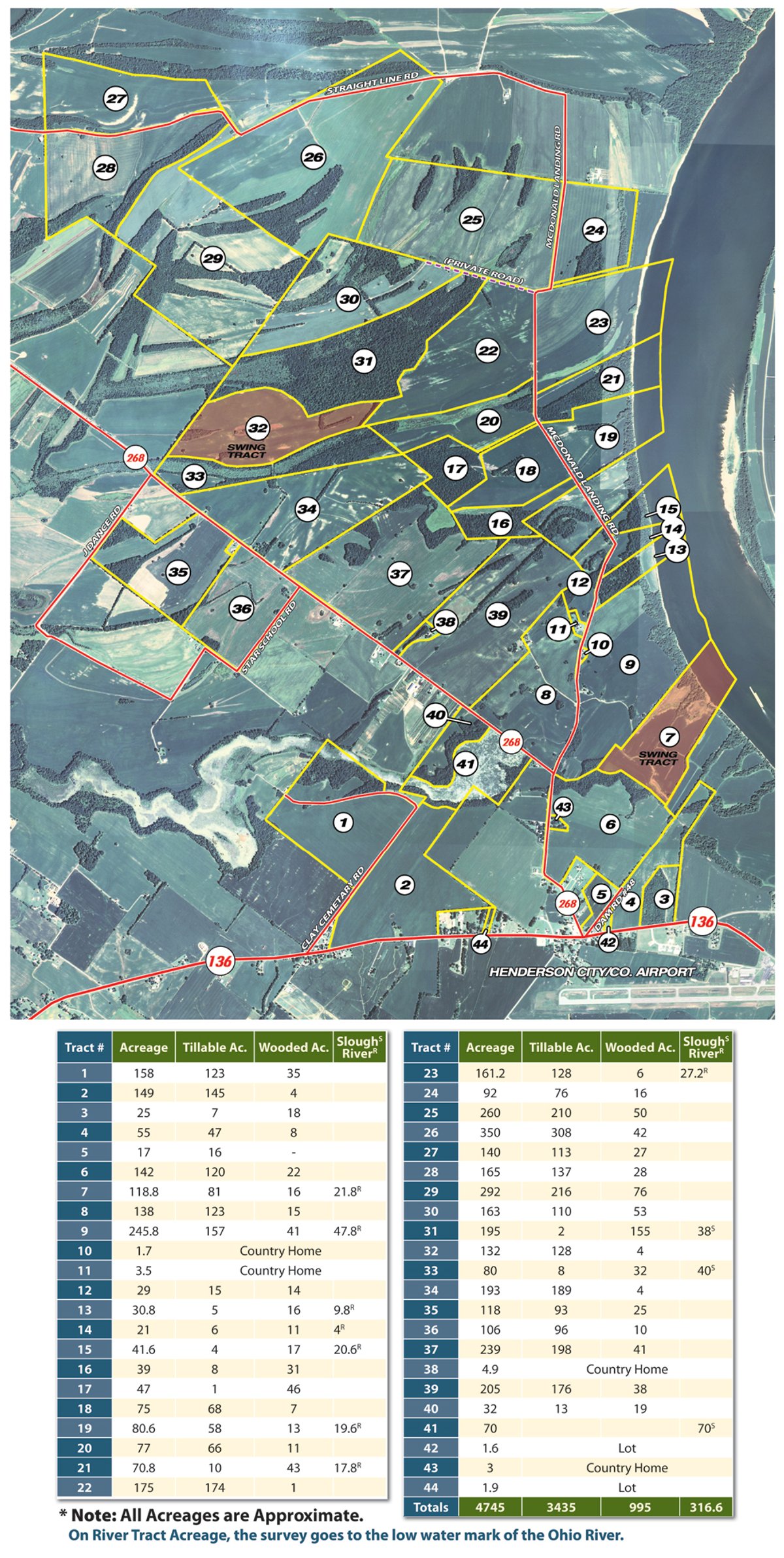
4,745 Acres Offered in 44 Tracts
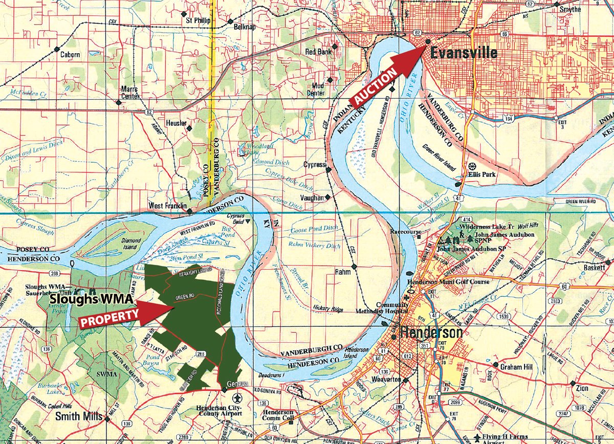
Henderson Kentucky - Along the Ohio River
Owner: Franklin Real Estate Company Wed, Oct 6, 2010 EASTERNAUCTION IS OVER
OPEN HOUSE/INSPECTION DATES
Wednesday, September 1 from 3pm - 6pm
Thursday, September 2 from 8am - 11am
Wednesday, September 15 from 3pm - 6pm
Thursday, September 16 from 8am - 11am
Wednesday, October 6 from 10am - Noon
INSPECTION HEADQUARTERS:
Henderson Co. Airport - 2154 Highway 136 West, Henderson, KY 42420
From the intersection of US Highway 60 and State Route 136 south of Henderson, Kentucky, travel west on State Route 136 for approximately 1 mile to the Henderson County Airport. Watch for signs.
PROPERTY LOCATION
From the intersection of US Highway 60 and State Route 136 south of Henderson, Kentucky, travel west on State Route 136 for approximately 1 mile to Geneva, Kentucky. Tracts 3 & 4 will be on the north side of the road, just across from the Henderson County Airport. Continue west on State Route 136 for Tracts 1-2. For the remainder of the tracts, at Geneva, Kentucky at the intersection of State Route 136 and State Route 268, travel north on State Route 268. Watch for Auction Tract signs.
AUCTION LOCATION
The Centre 715 Locust Street, Evansville, IN. 47708 Located on the corner of Locust Street and Martin Luther King, Jr. Blvd. In Downtown Evansville. Directions: From I-64 - Take US 41 South approximately 17 miles to the Lloyd Expressway Exit. Take the exit and turn to the right. Continue on the Lloyd Expressway to the Martin Luther King, Jr. Blvd. Exit. Take the MLK Blvd. exit and turn to the left, travel to the 5th stoplight which will be Locust Street. Turn left at the light and The Centre will be on your immediate right. From Henderson and locations South of Evansville - Take US 41 North and take the Lloyd Expressway exit. At the exit turn to the left and continue to the Martin Luther King, Jr. Blvd. Exit. Take the MLK Blvd. exit and turn to the left, travel to the 5th stoplight which will be Locust Street. Turn left at the light and The Centre will be on your immediate right.
PROPERTY DESCRIPTION
3,435 Acres Cropland
Productive Henderson County farmland featuring Wheeling silt loam (elk) as the predominate soil type on this property. According to USDA Natural Resources Conservation Service, Wheeling silt loam carries a soil rating of only 9 bushels/acre less than Ashton silt loam and Huntington silt loam which are the two most productive soils in the county. Wheeling silt loam (elk) is capable of producing 180-200 bushels of corn/acre and 60 bushels of soybeans/acre.
The 2010 crop includes corn, milo, soybeans, wheat and double crop soybeans (refer to pictures). Be sure to schedule an appointment to inspect the 2010 growing crop and the potential of crop production on this property! This area experienced heavy rainfall during the 2010 spring planting season, however, this property experienced little flooding compared to surrounding area. (Refer to aerial photos). The Henderson County Farm Service Agency (FSA) office shows a total of 3,455 acres of tillable land on this property. Refer to website for FSA and soil information.
Over 2 Miles of Scenic Ohio River Frontage
A mixture of wooded and open shoreline offers an amazingly diverse landscape, with lush foliage, mixed hardwoods, and tillable farmland. Each season brings its own drama - especially buds of spring, and the explosion of autumn colors, when the hardwoods put on one of nature's most impressive shows.
Prime Hunting / Deer, Goose & Duck
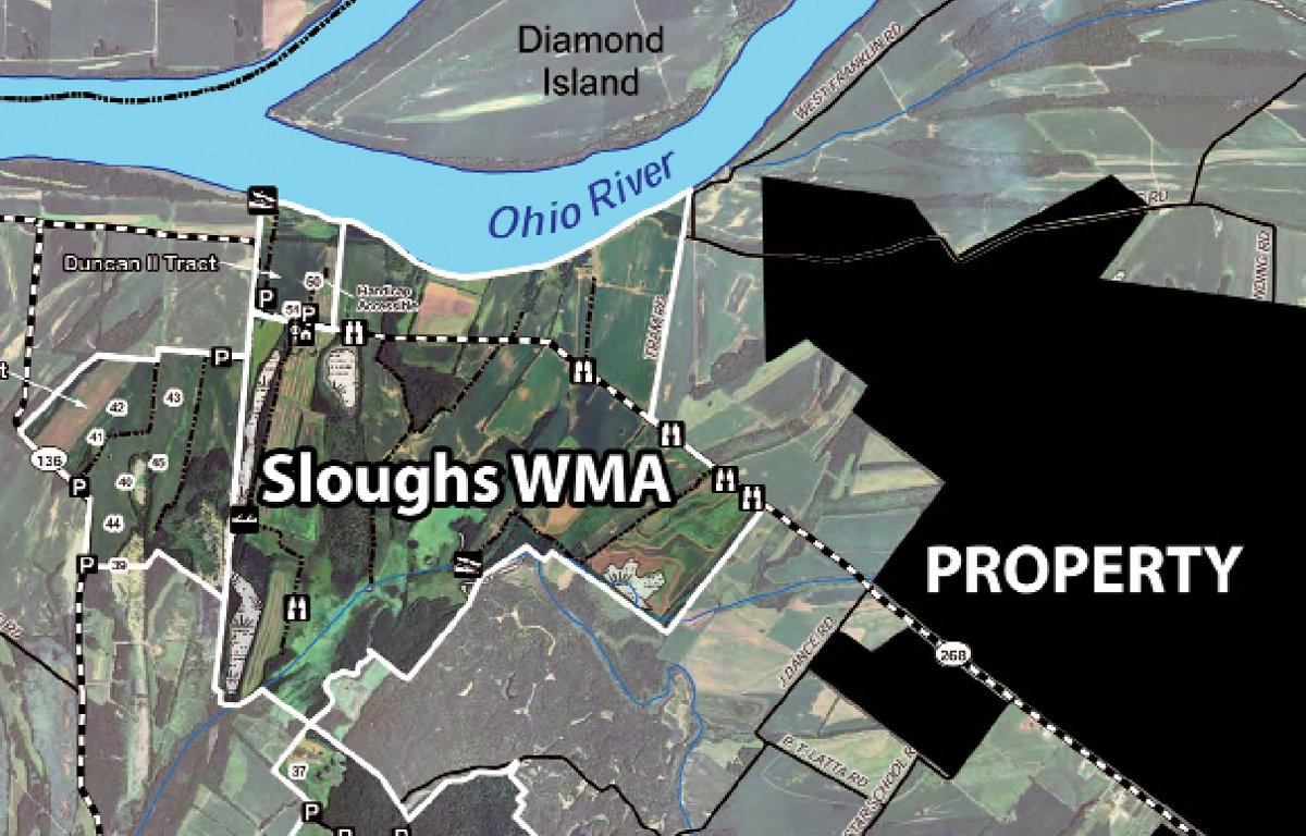
This could be some of the best combination hunting in the state of Kentucky featuring deer, goose and duck. The property is ideally located between the Ohio River and the Sloughs Wildlife Management Area. The Sloughs WMA consists of 10,998 acres of land which is Kentucky's second largest wildlife management area in the state providing excellent wildlife habitat.
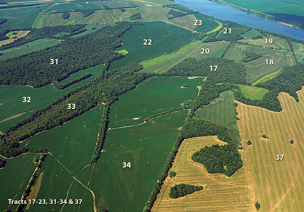
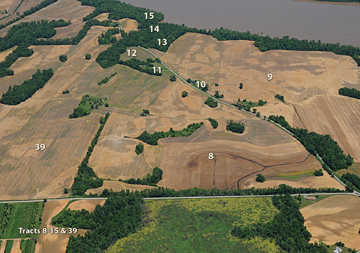
Tracts 13, 14, 15 and 21 are unique recreational/hunting tracts with frontage on the Ohio, easy access from McDonald Landing Road and high percentage of the acreage is mixed hardwood trees. Tracts 16, 17, 31 and 33 are larger woodland tracts with some slough areas providing excellent wildlife habitat for a variety of wildlife. Tract 41 is the largest slough area on the property providing excellent water fowl habitat. Investigate the potential of these tracts as excellent hunting and recreational tracts.
SLOUGHS WILDLIFE MANAGEMENT AREA
Sloughs Wildlife Management Area is located in Henderson and Union counties and contains approximately 10,000 acres, comprised of several tracts. Its main function is to provide outdoor recreational opportunities for various species of game. It contains a variety of habitats comprised of alternating ridges, sloughs, wetlands, woodlands, and crop lands. Kentucky's largest great blue heron rookery is on the area and up to 20,000 Canada geese and 10,000 ducks winter annually.
The quality habitats at Sloughs provide opportunities to view wildlife at several sites. The Sauerheber Unit is the refuge portion of the WMA and is focused for waterfowl. Although its interior is closed each year from Nov. 1-Mar. 15 five wildlife viewing
sites are provided along Hwy 268.
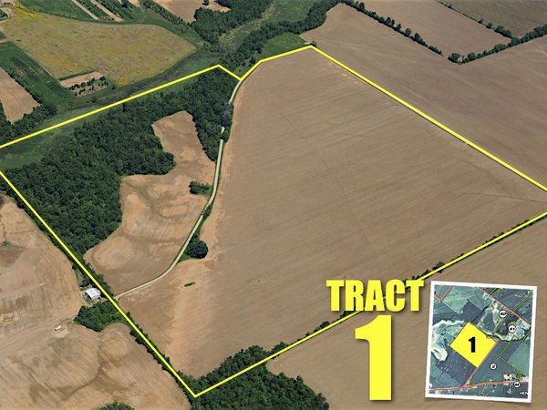
Click Here to Download High Resolution Tract Map.

AREA MAP
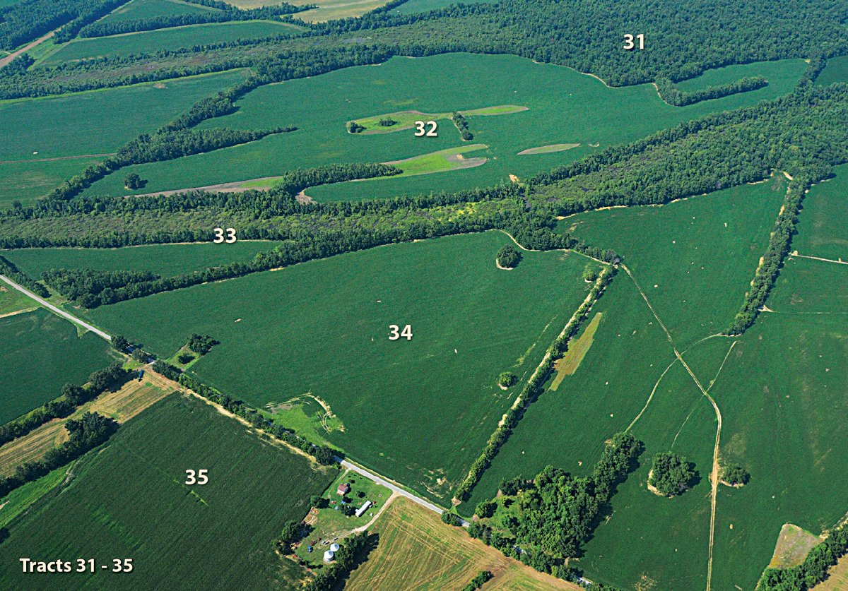
TRACT MAP(S)
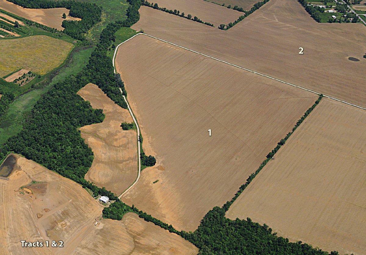
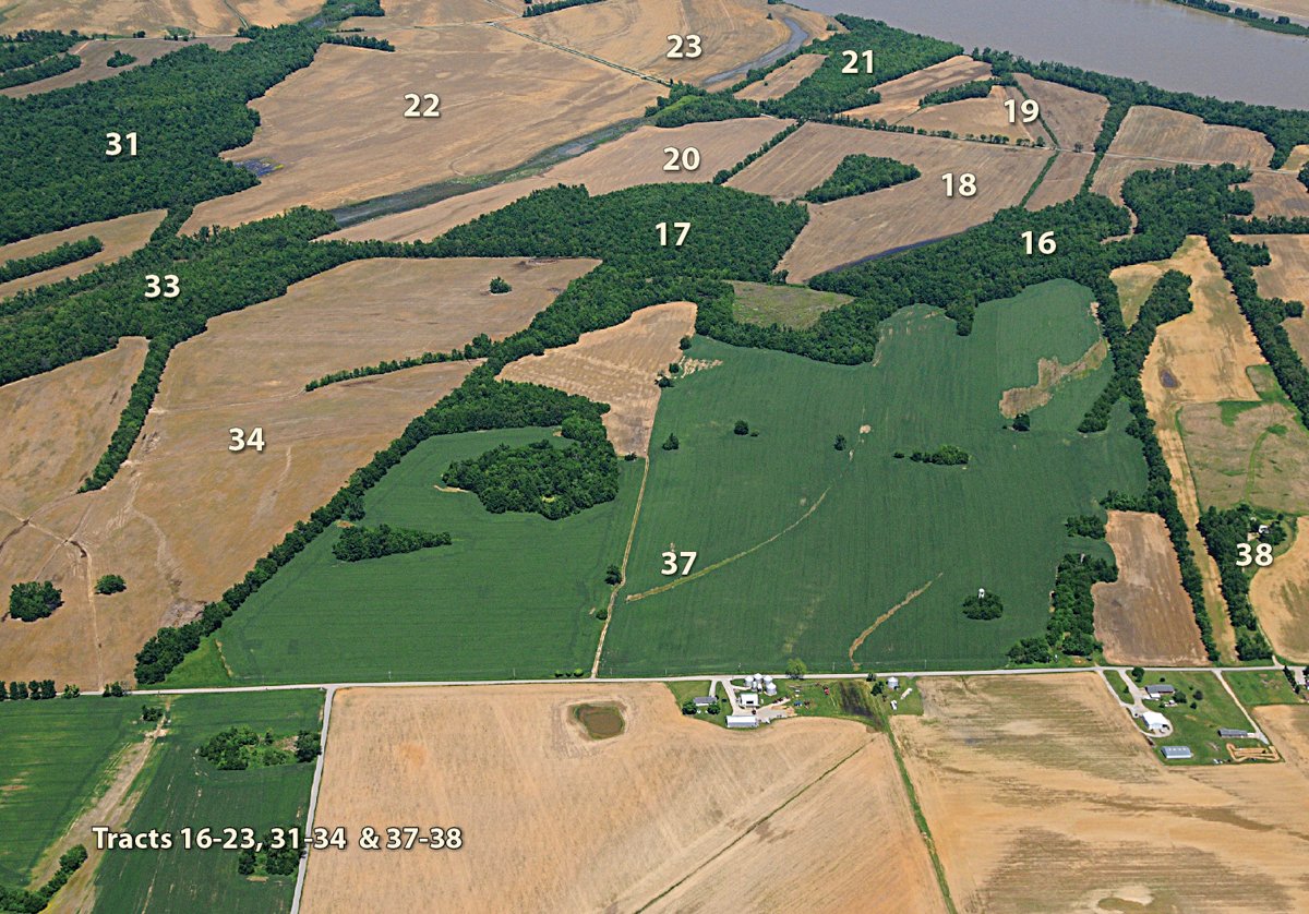
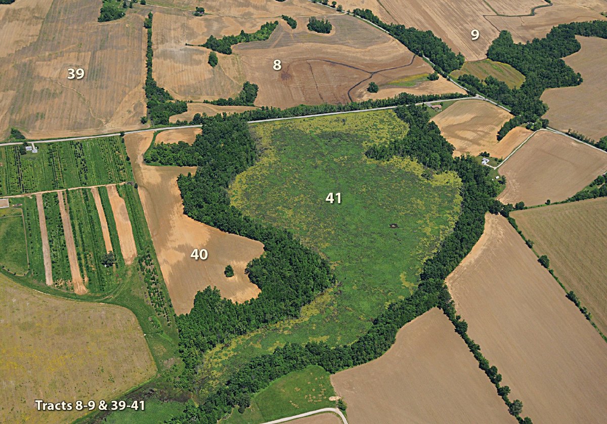
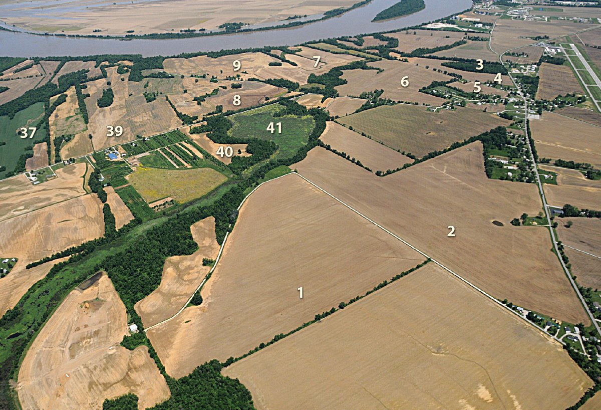
AREA MAP(S)
BUYER'S PREMIUM: A 3% buyer's premium will be added to the final bid price and included in the total purchase price.
PROCEDURE: The Property will be offered in 44 individual tracts, any combination of tracts and as a total unit at the dates and times as noted in this brochure. There will open bidding on all tracts and combinations during the auction as determined by the Auctioneers. Bids on tracts, tract combinations, and the total property may compete.
DOWN PAYMENT: 10% down payment on the day of auction with the balance in cash at closing. The down payment may be made in the form of cash cashier's check, personal check, or corporate check. YOUR BIDDING IS NOT CONDITIONAL UPON FINANCING SO BE SURE YOU HAVE ARRANGED FINANCING, IF NEEDED, AND ARE CAPABLE OF PAYING CASH AT CLOSING.
ACCEPTANCE OF BID PRICES: All successful bidders will be required to enter into a Purchase Agreement at the auction site immediately following the close of the auction. All final bid prices are subject to the Seller's acceptance or rejection.
PLANNING APPROVAL: All tract divisions are subject to approval by the Henderson City/County Plan Commission.
DEED: Seller shall provide a Special Warranty Deed.
EVIDENCE OF TITLE: The seller agrees to furnish Bidders a preliminary title insurance commitment to review prior to Auction. The cost of title insurance will be paid by the Seller. Seller agrees to provide merchantable title to the property subject to matters of record, general conditions of title, and similar or related matters. All tracts sold "AS IS".
REAL ESTATE TAXES: The Owner will pay the current year taxes prior to closing or pay taxes in the form of a credit to the Buyer(s) at closing. Owner shall credit Buyer(s) at closing for said taxes based on the most recent ascertainable tax figures.
CLOSING: Closing shall take place on or about December 1, 2010, or as soon thereafter as applicable closing documents are completed, at a location designated by Seller. With respect to the timing of bidder(s) fulfilling its obligations under a Purchase Agreement, time is of the essence.
POSSESSION: Possession of the land at closing, subject to tenants rights to harvest the 2010 crops on tillable land or Buyer(s) may have immediate possession after the auction for hunting privileges by signing a hunting lease which will expire at closing.
ACREAGE: All tract acreages, dimensions, and proposed boundaries are approximate and have been estimated based on current legal descriptions and/or aerial photos.
SURVEY: The Seller shall provide a new survey where there is no existing legal description or where new boundaries are created by the tract divisions in this auction. Any need for a new survey shall be determined solely by the Seller. Seller shall the cost of the survey. The type of survey performed shall be at the Seller's option and sufficient for the
issuance of an owner's title insurance policy. Combination purchases will receive a perimeter survey only. Closing prices shall be adjusted to reflect any difference between advertised and surveyed acres on all tracts and tract combinations.
PRIVATE ROAD MAINTENANCE: Tracts with frontage on the private roads included in the Property will be subject to a road maintenance agreement (and easements over the tracts for the private road) that will require contribution by owners of those tracts toward the maintenance of those roads.
PROPERTY INSPECTION: Each potential bidder is responsible for conducting at their own risk, their own independent inspections, investigations, inquires, and due diligence concerning the Property. Inspection dates have been scheduled and will be staffed with auction personnel. Bidder shall be liable for any Property damage caused by bidder's inspection and investigation, if any.
BROKER PARTICIPATION: Any licensed broker who properly registers the successful Bidder will be paid a fee of two percent (2%) based on the written opening bid amount with one percent (1%) paid on the difference between the written opening bid and the contract sales price (Bid Price plus Buyer's Premium). The Buyer Broker fee will be one percent (1%) if no written opening bid is made by a successful Buyer represented by a Broker. A Participating Broker must properly register his prospect in advance of the sale and is paid only if this prospect is the successful high Bidder.
AGENCY: Schrader Real Estate and Auction and Westchester, LLC. and their representatives are the Auctioneers and exclusive agents of the Seller regarding the sale of the Property.
DISCLAIMER AND ABSENCE OF WARRANTIES: All information contained in this brochure and all related materials are subject to the terms and conditions outlined in the Purchase Agreement. ANNOUNCEMENTS MADE BY THE AUCTIONEER AT THE AUCTION PODIUM DURING THE TIME OF THE SALE WILL TAKE PRECEDENCE OVER ANY PREVIOUSLY PRINTED MATERIAL OR ANY OTHER ORAL STATEMENTS MADE. The property is sold "AS IS, WHERE IS". No warranty or representation, either express or implied, or arising by operation of law concerning the Property is made by the Seller or Auctioneers, and are hereby expressly disclaimed. In no event shall Seller or the Auctioneers be liable for any consequential damages. The information contained in this brochure is believed to be accurate but subject to verification by all parties relying on it. Seller and the Auctioneers assume no liability for its accuracy, errors or omissions. All sketches and dimensions in this brochure are approximate. Conduct of the auction and increments of bidding are at the direction and discretion of the Auctioneers. Seller and the Auctioneers reserve the right to preclude any person from bidding if there is any question, in the sole judgment of Seller or the Auctioneers, as to such person's creditworthiness, ability or willingness to close on the purchase of the Property, credentials, fitness, etc. All decisions of the Auctioneers are final.
NEW DATA, CORRECTIONS AND CHANGES: Please arrive prior to scheduled auction time to inspect any changes, corrections, or additions to the Property information.
STOCK PHOTOGRAPHY: Some photography reflecting outdoor recreation activities are used for illustrative purposes.
SELLER: Franklin Real Estate Company


