


• PREMIER INDIANA SOILS • 1,357+/- FSA TILLABLE ACRES • SOIL FERTILITY MAPS AVAILABLE • SIGNIFICANT DRAINAGE IMPROVEMENTS • IRRIGATED FARMLAND ACQUISITION OPPORTUNITY • GRAIN STORAGE FACILITY • CAPABLE OF PRODUCING 250BPA DRY CORN YIELD AVERAGES

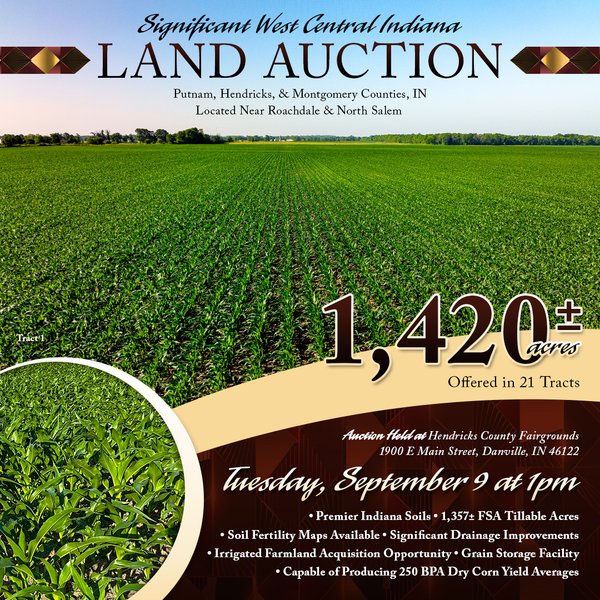
LAND AUCTION - 1,420 ACRES OFFERED IN 21 TRACTS IN PUTNAM, HENDRICKS & MONTGOMERY COUNTIES, INDIANA
Roachdale and North Salem, IN - Putnam, Hendricks & Montgomery Counties, Indiana
Owner: Britton Farms Inc. & TRB Farms LLC Tue, Sep 9, 2025 EASTERNAUCTION IS OVER
TOTAL SOLD: $20,820,000
| Tract(s): 1-3+6+7+10 | @ $7,110,000 | ($14,684/acre) |
| Tract(s): 4 | @ $675,000 | ($14,674/acre) |
| Tract(s): 5 | @ $400,000 | |
| Tract(s): 8+9 | @ $1,700,000 | ($14,567/acre) |
| Tract(s): 11 | @ $690,000 | ($15,000/acre) |
| Tract(s): 12-19 | @ $9,855,000 | ($14,777/acre) |
| Tract(s): 20+21 | @ $390,000 | ($6,806/acre) |
This is a rare offering to purchase prime tillable farmland that has been highly maintained & improved. Britton Farms is known for their love of farming & improving the land through various types of management practices. Many of the tracts have been improved with controlled drainage management systems. Waterlines have been put in place to utilize the ample water resources for both center pivot irrigation & subsurface irrigation by way of the controlled drainage management systems. For more information please contact the Auction Company for a detailed Information Book that includes, drainage information, FSA Maps, Soil Maps, & any other information pertinent to the auction!
OPEN HOUSE/INSPECTION DATES
Information Dates (Held at Roachdale Community Building, Roachdale, IN):
Thursday July 24, 2025 from 10am-12pm
Wednesday August 6, 2025 from 4-6pm
Thursday August 28, 2025 from 10am-12pm
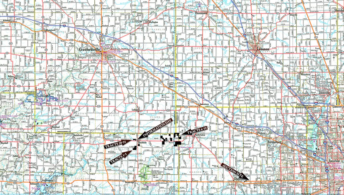
PROPERTY LOCATION
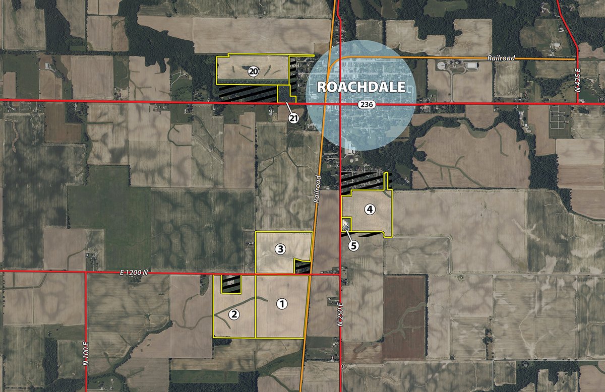
From the Intersection of State Rd 236 & Indiana St (County Rd 250 S) in Roachdale:
Tracts 1-5: Travel South on Indiana St (County Rd 250) for .2 miles & Tract 4 will begin on the left (East). To Tracts 1-3 continue South on County Rd 250 South to County Rd 1200 N. Turn right (West) on County Rd 1200 N Tracts 1-3 will begin in .2 miles.
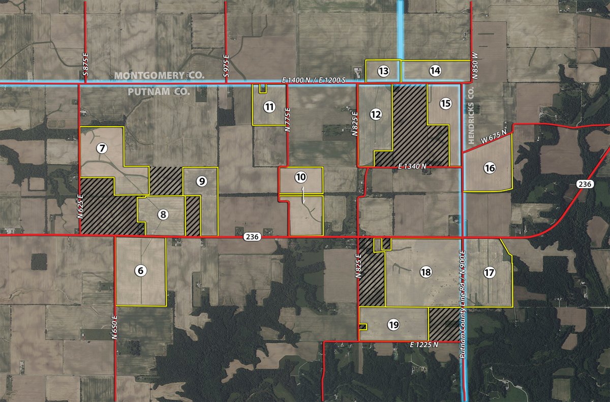
Tracts 6-19: Travel East of State Rd 236 for 4.1 miles & Tracts 6 & 8 will begin on the North & South side of the road. As you continue East on State Rd 236 look for signs to additional Tracts North & South of 236.
Tract 20: Travel North on N Indiana St for .1 miles to North Spring St turn left (West). Travel West on Spring St for .3 miles & the road will dead end at the entrance to the property (see signs).
Tract 21: Travel West on State Rd 236 for .2 miles & the property
will start on the North side of the road.
AUCTION LOCATION
Hendricks County Fairgrounds
1900 E Main St, Danville, IN 46122
PROPERTY DESCRIPTION
1,420+/-acres of mostly tillable land with grain bin storage offered in 21 tracts.
Controlled Drainage Management Systems: A Controlled drainage water system is a management practice that regulates the water table in agricultural fields by using inline water control structures that manage the outlet elevation of drainage systems. This allows the producer to have control over the timing & volume of water leaving the field, retaining water during periods when drainage is not needed & reduce nutrient loss through drainage water. For more details of how these systems work please call the Auction Manager or refer to the Auction Information Book.
Irrigation Wells: T his farm has (2) 12" high-capacity irrigation wells capable of pumping 1000 gal/minute. Both wells are 240' deep, with a pump set near the bottom of the wells in a pool of water 40' deep. Both wells are serviced by 3 phase power & 125 hp electric motors. The west well is located on Tract 11 & the East well is located on Tract 13. DNR Division of Water documented May 2025 a static water level of 24.2 ft on the West well & a static water level of 30.2' on East well. These wells are located in a significant aquifer area.
Irrigation: As a whole Britton Farms offers 760+/- Irrigated acres, with a mixture of subsurface & center pivot irrigation. The irrigated acres are serviced by two wells; the West well located on Tract 11 & the East well located on Tract 13. The West well services Tracts 6-11 & East well services tracts 13-19. In order to continue to utilize the irrigation infrastructure in place, you must purchase the tracts in the order that they are serviced by the well via underground piping. For the West well you must include Tract 11 descending to Tract 6 or any lessor combination ascending in order to Tract 11. For the East well you must include Tract 13 ascending to Tract 19 or any lessor ascending combination in order from Tract 13. For questions & more information on the offering please contact the Auction Company!
Grain Storage Facility Details:

TRACT DESCRIPTIONS
Tract 1: 72± ac Ragsdale silt loam & Reesville silt loam. 72+/- acres FSA tillable. Ragsdale silt loam, one of the highest rated soils in the state.
Tract 2: 52.4± ac Ragsdale silt loam & Reesville silt loam. 50+/- acres FSA tillable. See the Information Book for tile maps on Tracts 1 & 2.
Tract 3: 49.4± ac Ragsdale silt loam & Reesville silt loam. 47.31+/- acres FSA tillable. Combine tracts 1-3 for 173.38 acres of prime production farm-land just south of Roachdale!
Tract 4: 46± ac 98% Ragsdale silt loam & Reesville silt loam. 43.77+/- acres FSA tillable. Tile map is available in the Information Book.
Tract 5: 3.2± ac 202,000 Bushels of Grain Storage, 1,000 BPH Continuous flow dryer, 3 phase electric, natural gas service, 42'x54' insulated machine shed & additional lean to storage.
Tract 6: 120± ac Ragsdale silt loam & Reesville silt loam. 116.38+/- acres FSA tillable. 2 Pivot points available with 4 tower T&L towable center pivot, tile maps available in the information book.
Tract 7: 103.9± ac Reesville silt Loam, Ragsdale silt loam & Russell silt loam. 95.33+/- acres FSA tillable. (2) Pivot points available (contact Auction Company for tile map).
Tract 8: 60.7± ac 95% Ragsdale silt loam & Reesville silt loam. 60.08+/- acres FSA tillable. (1) Pivot point available.
Tract 9: 56± ac Ragsdale silt loam & Reesville silt loam. 56.16+/- acres FSA tillable. Southern 24 acres has controlled drainage system in place, see the Information Book for more details on field drainage.
Tract 10: 86.5± ac Ragsdale silt loam & Reesville, silt loam. 85.01+/- acres FSA tillable. (1) 3 Tower T&L irrigation systems.
Tract 11: 46± ac Ragsdale silt loam & Reesville silt loam. 45.94+/- acres FSA tillable. 12" irrigation well, 240" deep located in a significant aquifer (refer to commentary).
Tract 12: 85.6± ac Ragsdale silt loam & Reesville silt loam. 82.41+/- acres FSA tillable. Road frontage on 2 roads - long rows efficient for large equipment.
Tract 13: 26.3± ac 72% Ragsdale silt loam. 24.48+/- acres FSA tillable. 12' irrigation well in a significant aquifier capable of pumping 1000 gal. per minute, controlled drainage system in place refer to the Information Book for details.
Tract 14: 51.4± ac 99% Ragsdale silt loam & Fin-castle silt loam. 50.41+/- acres FSA tillable. Controlled drainage management system (sub surface irrigation), see information Book for tile maps.
Tract 15: 66.9± ac Ragsdale silt loam & Reesville silt loam. 64.59+/- acres FSA tillable. Road frontage on 2 roads, long row.
Tract 16: 80.3± ac 97% Ragsdale Silt Loam & Fin-castle silt loam. 76.94+/- acres FSA tillable. Controlled drainage management system (sub surface irrigation), call for tile map.
Tract 17: 102.4± ac 71% Fincastle Silt Loam & 18% Ragsdale silt clay loam. 99.92+/- acres FSA tillable. 4 tower T&L towable center pivot serves 2 pivot points, tile map available.
Tract 18: 177± ac Ragsdale silt loam & Reesville silt loam. 172.78+/- acres FSA tillable. Controlled drainage management system (sub surface irrigation), See Information Book for more information on Tiling.
Tract 19: 77± ac Ragsdale silt loam & Reesville silt loam. 76.71+/- acres FSA tillable. Controlled drainage management system (sub surface irrigation), See Information Book for more information on Tiling.
Tract 20: 51.1± ac Miami clay loam, Shals silt loam, Xenia silt loam & Reesville silt loam. 37.08+/- acres FSA tillable. Tile map available,systematically tiled in 2010.
Tract 21: 6.2± ac Shoals silt loam, Hennepin loam, Xenia silt loam. Mixed hardwood trees, road frontage on State Road 236.
TRACT MAP(S)
AREA MAP(S)
BIDDING PROCEDURE: The property will be offered in 21 individual tract & combinations. Britton Farms Inc. (Tracts 1-19) total 1363.5+/- Acres & TRB Farms LLC (Tracts 20-21) total 56.5+/- Acres. There will be open bidding on each individual tract, as well as combinations of tracts for Tracts 1-19 & Tracts 20-21. Tracts 1-19 can be combined as a unit, but cannot be combined at any point with Tracts 20-21.
ACCEPTANCE OF BIDS: Each successful bidder will be required to sign a purchase contract, in the form provided in the bidder packets, at the auction site immediately following the close of the auction. All information contained in this sale brochure & other marketing materials is subject to the terms & conditions contained in the written purchase contract. Seller shall not be bound by any statement, promise or inducement that is not contained or incorporated in the written purchase contract. All final bid prices are subject to the Seller's acceptance or rejection.
PAYMENT TERMS: 10% of the purchase price will be due as a down payment on the day of auction, with the balance due in cash at closing. The down payment may be made in the form of a cashier's check, personal check, or corporate check. YOUR BIDDING IS NOT CONDITIONAL UPON FINANCING, so be sure you have arranged financing, if needed, & are capable of paying cash at closing.
TAXES: Seller to pay estimated 2025 taxes due in 2026. Buyer shall pay all subsequent real estate taxes to the extent attributed to the purchased tracts.
POSSESSION: The possession of the farmland will be given at closing, subject to the removal of the 2025 crop. Possession of the grain handling system will be given on August 1, 2026 or at the time of written notice by landlord & tenant that all grain & personal property are removed.
EVIDENCE OF TITLE: Preliminary title insurance schedules will be available for review prior to the auction. At closing, Seller will pay for the issuance of a standard owner's title insurance policy in the amount of the purchase price.
CLOSING: The targeted closing date will be approximately 30-45 days after the auction. This time-line can change based on completion of any survey if needed where there is no legal description to convey the property.
DEED: Seller shall provide Special Warranty Deed(s).
TRACT MAPS; ACRES: All advertised tract maps, acres, dimensions & boundaries are approximations based on county parcel data, current legal descriptions, FSA Mapping, and/or aerial mapping. The marketing materials are not provided as survey products.
PROPERTY INSPECTION: Each potential Bidder is responsible for conducting, at their own risk, their own independent inspections, investigations, inquiries & due diligence concerning the property. Inspection dates have been scheduled & will be staffed with auction personnel. Further, Seller disclaims any & all responsibility for Bidder's safety during any physical inspection of the property. No party shall be deemed an invitee of the property by virtue of the offering of the property for sale.
SURVEY: The Seller shall provide a new survey where there is no existing legal description or where new boundaries are created by the tract divisions in this auction. Any need for a new survey shall be determined solely by the Seller. Seller & successful bidder shall each pay half (50:50) of the cost of the survey. The type of survey performed shall be at the Seller's option & sufficient for providing title insurance.
AGENCY: Schrader Real Estate & Auction Company, Inc. & its representatives are exclusive agents of the Seller.
DISCLAIMER & ABSENCE OF WARRANTIES: All information contained in this brochure & all related materials are subject to the terms & conditions outlined in the Purchase Agreement. The property is being sold on an "AS IS, WHERE IS" basis, & no warranty or representation, either expressed or implied, concerning the property is made by the Seller or the Auction Company. All sketches & dimensions in the brochure are approximate. Each potential bidder is responsible for conducting his or her own independent inspections, investigations, inquiries, & due diligence concerning the property. The information contained in this brochure is subject to verification by all parties relying on it. No liability for its accuracy, errors, or omissions is assumed by the Seller or the Auction Company. Conduct of the auction & increments of bidding are at the direction & discretion of the Auctioneer. The Seller & Selling Agents reserve the right to preclude any person from bidding if there is any question as to the person's credentials, fitness, etc. All decisions of the Auctioneer are final.
ANY ANNOUNCEMENTS MADE THE DAY OF THE SALE TAKE PRECEDENCE OVER PRINTED MATERIAL OR ANY OTHER ORAL STATEMENTS MADE.
 Online Pre-Registration Form Link
 Online Bidder Registration Form
Prelim. Title Ins. Schedules (with exception docs) - Tracts 1-5
Prelim. Title Ins. Schedules (with exception docs) - Tracts 12-19
Prelim. Title Ins. Schedules (with exception docs) - Tracts 20-21
Prelim. Title Ins. Schedules (with exception docs) - Tracts 6-11
Click to access


