


• Productive Tillable Land • Farm Home with Outbuildings • 10 Miles Southeast of Muncie • 12 Miles to New Castle • 14 Miles to Winchester • Between Prairie Creek Reservoir and Summit Lake State Park • Unique Recreational Land with Pond

95.3 Acres Offered in 4 Tracts - Real Estate Auction
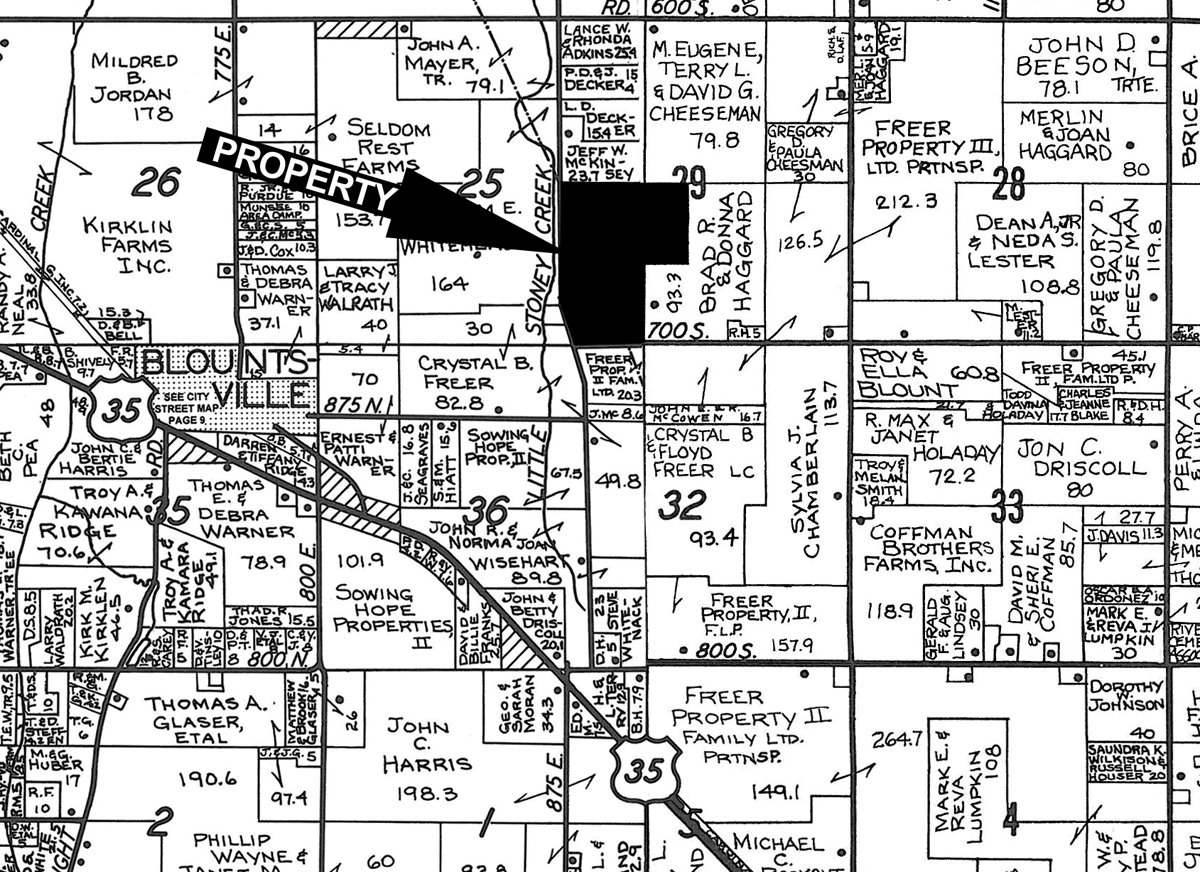
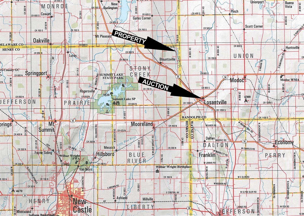
Henry and Randolph County- IN. Northeast of New Castle - Near Blountsville
Owner: Paul and Elizabeth Miller Wed, Nov 21, 2012 EASTERNAUCTION IS OVER
TOTAL SOLD: $485,000
| Tract(s): 1+2 | @ $363,000 | ($5,113/acre) |
| Tract(s): 3+4 | @ $122,000 | ($5,021/acre) |
OPEN HOUSE/INSPECTION DATES
Thursday, November 8, 3-5 p.m.
Saturday, November 10, 9-11 a.m.
Meet at the home on Tract 3
PROPERTY LOCATION
Located at the intersection of CR 875E and CR 900N in Northeastern Henry County. Property is 1 mile east and 1/2 mile north of Blountsville. From Muncie, south on US 35 about 7 mi. to CR 800S, then east 2-3/4 mi. to CR 875E, then south 1/2 mi. to the farm.
AUCTION LOCATION
Losantville Fire Station, 111 N. Main St., Losantville, IN
TRACT DESCRIPTIONS
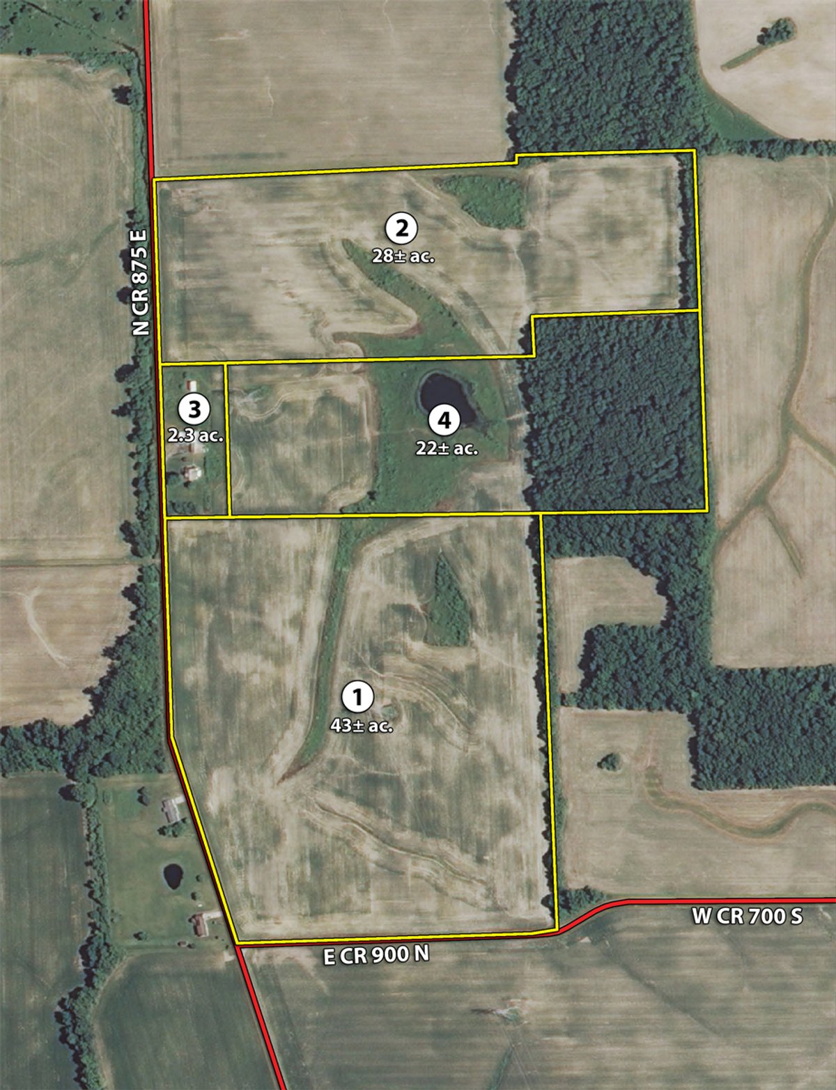
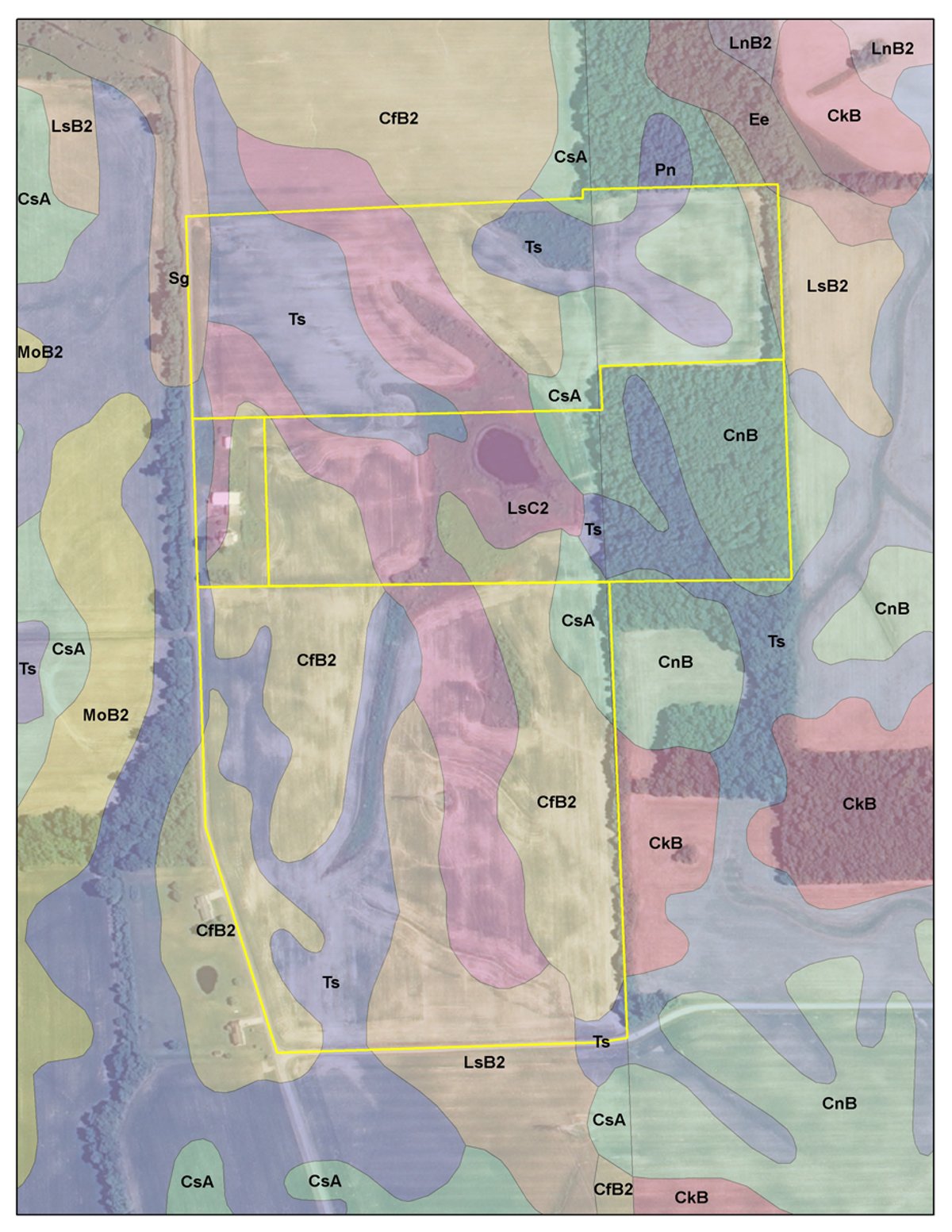
Tract 1: 43± ac About 40 acres tillable. Quality parcel with Treaty, Celina and Losantville soils. Perfect to add to your operation. Frontage on CR 875E and CR 900N.
Tract 2: 28± ac Approximately 24 ac. tillable. Gently rolling parcel with Treaty, Celina, Crosby and Losantville soils. Frontage on CR 875E with drainage outlet across roadway.
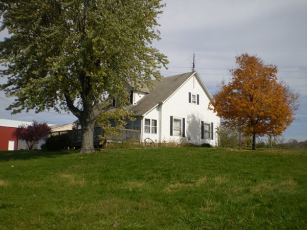
Tract 3: 2.3± ac 9170 N CR 875 E, Losantville. 2-story Country home with outbuildings in a nice setting. Home has 2484 sq. ft., 5 BR w/ 2 bath, large kitchen, walk-in closets, enclosed porch, wood deck, hot water heat, new septic system. Separate entrance offers potential to be a 2-family home. Pole barn (built in 2002) measures 36x80. Smaller barn has concrete floor and O/H doors. Frontage on CR 875 E.
Tract 4: 22± ac Approximately 7.5 acres tillable with attractive pond and the balance in woods. This swing tract must be purchased by an adjacent landowner or in combination with another tract. Great recreation tract.
AREA MAP
TRACT MAP(S)
SOIL INFORMATION
PLAT MAP(S)
AREA MAP(S)
PROCEDURES: The property will be offered in 4 individual tracts, any combination of tracts, or as a total 95.3+ acre unit. Tract 4: Swing Tract 22 +/- acres must be purchased in combination with adjoining tracts or by adjoining owner. There will be open bidding on all tracts and combinations during the auction as determined by the Auctioneer. Bids on tracts, tract combinations and the total property may compete.
DOWNPAYMENT: Real Estate 10% down payment on the day of the auction with the balance in cash at closing. The down payment may be made in the form of cash; cashiers check, personal check or corporate check. Your bidding is not conditional upon financing, so be sure you have arranged financing, if needed and are capable of paying cash at closing.
ACCEPTANCE OF BID PRICES: Successful bidder(s) will be required to enter into a purchase agreement at the auction site immediately following the close of the auction. All final bid prices are subject to the Sellers acceptance or rejection.
EVIDENCE OF TITLE: Sellers shall provide an owners title insurance policy in the amount of the purchase price.
DEED: Sellers shall provide Warranty Deed.
CLOSING: The balance of the real estate purchase price is due at closing, which will take place within 15 days of presentation of title policy estimated on or before December 27, 2012.
POSSESSION: At closing. Buyer to receive 2013 crop rights.
REAL ESTATE TAXES: Seller pays 2012 due 2013 taxes. Buyer will assume all taxes due May 2014 and thereafter. 2011 payable 2012 taxes were $2932. No ditch assessments. Contact auction manager for tax estimates per tract.
ACREAGE: All boundaries are approximate and have been estimated based on current legal descriptions.
SURVEY: A new survey will be made where there is no existing legal description or where new boundaries are created by the tract divisions in this auction. Buyer(s) and Seller will share survey expense 50:50. Combination purchases will receive a perimeter survey only. Closing prices will be adjusted to reflect any differences between advertised and surveyed acreages.
FSA INFORMATION: 71.5 Acres Total Cropland. Farm #6268. Corn base of 35.0 ac., Soy base 35.0 ac.
EASEMENTS: Sale of the property is subject to any and all easements of record.
MINERAL RIGHTS: The sale shall include 100% of the mineral rights owned by the Seller.
AGENCY: Schrader Real Estate and Auction Company, Inc. and its representatives are exclusive agents of the seller.
DISCLAIMER AND ABSENCE OF WARRANTIES: All information contained in this brochure and all related materials are subject to the Terms and Conditions outlined in the Purchase Agreement. The property is being sold on AS IS, WHERE IS basis, and no warranty or representation, either express or implied, concerning the property is made by the seller or the auction company. Each potential bidder is responsible for conducting his or her own independent inspections, investigations, inquiries, and due diligence concerning the property. The information contained in this brochure is subject to verification by all parties relying on it. No liability for its accuracy, errors or omissions is assumed by the Sellers or the Auction Company. Conduct of the auction and increments of bidding are at the direction and discretion of the Auctioneer. The Sellers and Selling Agents reserve the right to preclude any person from bidding if there is any question as the persons credentials, fitness, etc. All decision of the Auctioneer is final.
ANY ANNOUNCEMENTS MADE THE DAY OF THE SALE TAKE PRECEDENCE OVER PRINTED MATERIAL OR ANY OTHER ORAL STATEMENTS MADE. AUCTION COMPANY OR OWNER NOT RESPONSIBLE FOR ACCIDENTS.

Click to access


