


• 10+/- MILES SOUTHEAST OF HILLSDALE, MI • 8+/- MILES NORTH OF PIONEER, OH • PRODUCTIVE TILLABLE LAND • EXCELLENT FRONTAGE ON 3 ROADS • POTENTIAL BUILDING SITES


LAND AUCTION - 122+/- ACRES OFFERED IN 7 TRACTS IN HILLSDALE COUNTY, MICHIGAN
Tamarack Rd, Ransom, MI 49271 - Hillsdale County, Michigan
Owner: Stoney Acres Land, LLC, Joseph B. Draper and Angela N. Draper Living Trust, DDAJ Land LLC Mon, Dec 15, 2025 EASTERNAUCTION IS OVER
TOTAL SOLD: $927,000
| Tract(s): 1-4 | @ $592,912 | ($7,801/acre) |
| Tract(s): 5-7 | @ $334,088 | ($7,263/acre) |
OPEN HOUSE/INSPECTION DATES
Tuesday November 25, 2025 from 10am-12pm
Thursday December 11, 2025 from 2-4pm
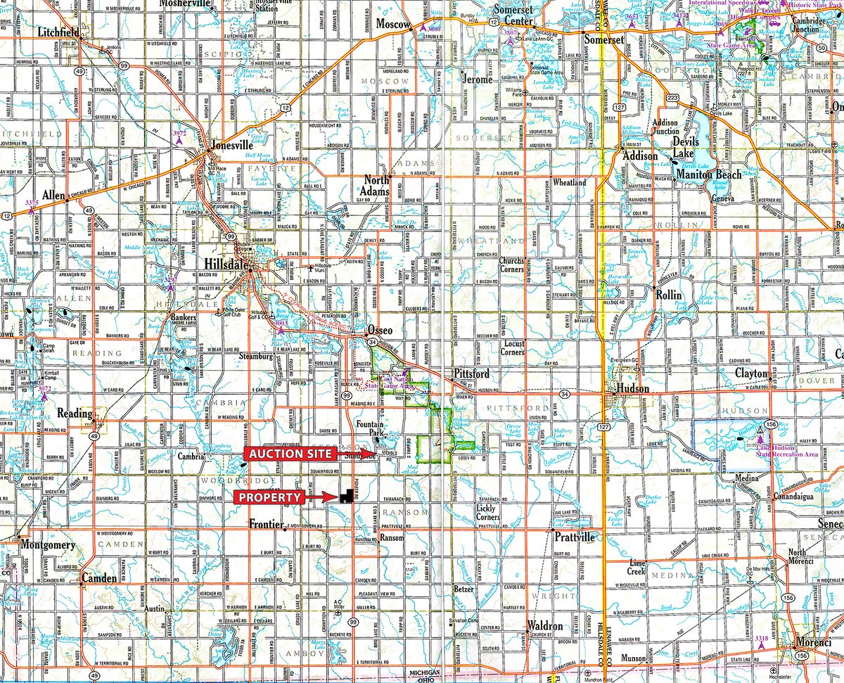
PROPERTY LOCATION
Tamarack Rd, Ransom, MI 49271
From Hillsdale travel South on M-99 11+/- miles -or- from Pioneer, OH travel North 8.5+/- miles on M-99 to property at Tamarack Rd. Farm has frontage on M-99, Tamarack and Lake Pleasant Road to the West.
AUCTION LOCATION
Bird Lake Christian Academy
7260 Bird Lake Rd S, Osseo, MI 49266
PROPERTY DESCRIPTION
Mostly all tillable with good productive soils and gently rolling topography. Mostly Williamstown Conover, Wawasee Loam and Wolcott Silt Loam soils. Potential building sites with great frontage on 3 sides: M-99 (Pioneer Rd), Tamarack Rd and Lake Pleasant Rd. Imagine the possibilities!
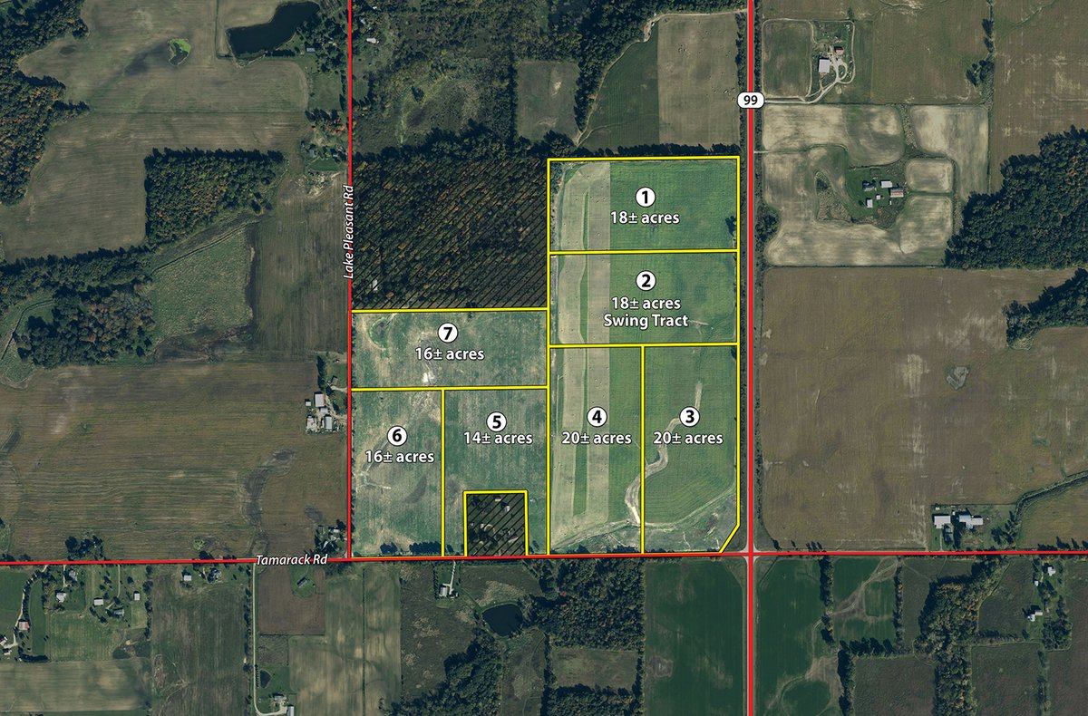
TRACT DESCRIPTIONS
Tract 1: 18± ac mostly tillable with a small amount of wooded area in the NW corner. Recreational and homesite potential with frontage on M-99.
Tract 2: 18± ac "swing" tract mostly tillable. This Tract must be combined with another adjoining tract in the auction and cannot be purchased by itself.
Tract 3: 20± ac mostly tillable w/frontage on M-99 and Tamarack Rd.
Tract 4: 20± ac mostly tillable w/frontage on Tamarack Rd. Consider combining with Tracts 2 and 3.
Tract 5: 14± ac mostly tillable w/frontage on Tamarack Rd.
Tract 6: 16± ac mostly tillable w/frontage on the corner of Tamarack and Lake Pleasant.
Tract 7: 16± ac mostly tillable w/frontage on Lake Pleasant Rd. Nice setting up against a neighboring woods.
TRACT MAP(S)
AREA MAP(S)
PROCEDURE: The property will be offered in 7 individual tracts or any combination of tracts (subject to "swing" tract limitations) within groups of Tracts 1-4 or 5-7. There will be open bidding on all tracts and combinations during the auction as determined by the Auctioneer. Bids on tracts and tract combinations may compete.
BUYER'S PREMIUM: A 3% Buyer's Premium will be added to the final bid price and included in the contract purchase price.
DOWN PAYMENT: 10% down payment on the day of auction for individual tracts or combinations of tracts. The down payment may be made in the form of cashiers check, personal check, or corporate check. YOUR BIDDING IS NOT CONDITIONAL UPON FINANCING, so be sure you have arranged financing, if needed, and are capable of paying cash at closing.
ACCEPTANCE OF BID PRICES: All successful bidders will be required to enter into Purchase Agreements at the auction site immediately following the close of the auction. All final bid prices are subject to the Sellers acceptance or rejection.
EVIDENCE OF TITLE: Seller shall provide an owners title insurance policy in the amount of the purchase price.
DEED: Property to be conveyed by Warranty Deeds.
CLOSING: The targeted closing date will be approximately 30 days after the auction.
POSSESSION: At closing, subject to the harvest of the 2025 growing crop.
REAL ESTATE TAXES: Sellers pay the Winter taxes due in December 2025 with Buyers to pay taxes thereafter.
PROPERTY INSPECTION: Each potential Bidder is responsible for conducting, at their own risk, their own independent inspections, investigations, inquiries and due diligence concerning the property. Inspection dates have been scheduled and will be staffed w/ auction personnel. Further, Seller disclaims any and all responsibility for Bidders safety during any physical inspection of the property. No party shall be deemed an invitee of the property by virtue of the offering of the property for sale.
ACREAGE: All tract acreages, dimensions, and proposed boundaries are approximate and have been estimated based on current legal descriptions and/or aerial photos.
SURVEY: The Seller shall provide a new survey where there is no existing legal description or where new boundaries are created by the tract divisions in this auction. Any need for a new survey shall be determined solely by the Seller. Seller and successful bidder shall each pay half (50:50) of the cost of the survey. The type of survey performed shall be at the Sellers option and sufficient for providing title insurance. Combination purchases will receive a perimeter survey only.
AGENCY: Schrader Real Estate and Auction Company, Inc. and its representatives are exclusive agents of the Seller.
DISCLAIMER AND ABSENCE OF WARRANTIES: All information contained in this brochure and all related materials are subject to the terms and conditions outlined in the Purchase Agreement. The property is being sold on an "AS IS, WHERE IS" basis, and no warranty or representation, either expressed or implied, concerning the property is made by the Seller or the Auction Company. All sketches and dimensions in the brochure are approximate. Each potential bidder is responsible for conducting his or her own independent inspections, investigations, inquiries, and due diligence concerning the property. The information contained in this brochure is subject to verification by all parties relying on it. No liability for its accuracy, errors, or omissions is assumed by the Seller or the Auction Company. Conduct of the auction and increments of bidding are at the direction and discretion of the Auctioneer. The Seller and Selling Agents reserve the right to preclude any person from bidding if there is any question as to the persons credentials, fitness, etc. All decisions of the Auctioneer are final.
ANY ANNOUNCEMENTS MADE THE DAY OF THE SALE TAKE PRECEDENCE OVER PRINTED MATERIAL OR ANY OTHER ORAL STATEMENTS MADE.


