

Sold
47.5+/- ACRES LAND AUCTION OFFERED IN 5 TRACTS IN KOSCIUSKO COUNTY INDIANA
825 N Leesburg, IN-Kosciusko County Indiana · Owner: Phillip Kent Huffman & Jacqueline Ann Weber
- Auction dateMon, Nov 25, 2024 ET
- Acres47.5±
- Tracts5
- Auction held atMt. Tabor Church of God Fellowship Hall,
8424 N 800 W, Etna Green, IN 46524

Total Sold: $950,000
| Tract(s) | Sold for | Per acre |
|---|---|---|
| 1-5 | $950,000 | $20,000/acre |
Own land nearby?
These are real results from this sale, not estimates. Ask Joe Kessie and Luke Schrader, who managed this auction, what your land would bring in today's market. There is no obligation.
- GREAT POTENTIAL HOME & MINI FARM BUILDING SITES
- NAPPANEE AREA
- PRODUCTIVE FARM LAND
- TRACTS ARE 6-15+/- ACRES
- 44.94 FSA CROPLAND ACRES
- HIGH QUALITY SOIL
Open house / inspection dates
Wednesday October 30, 2024 from 3-5pm
Wednesday November 20 from 3-5pm
Property location
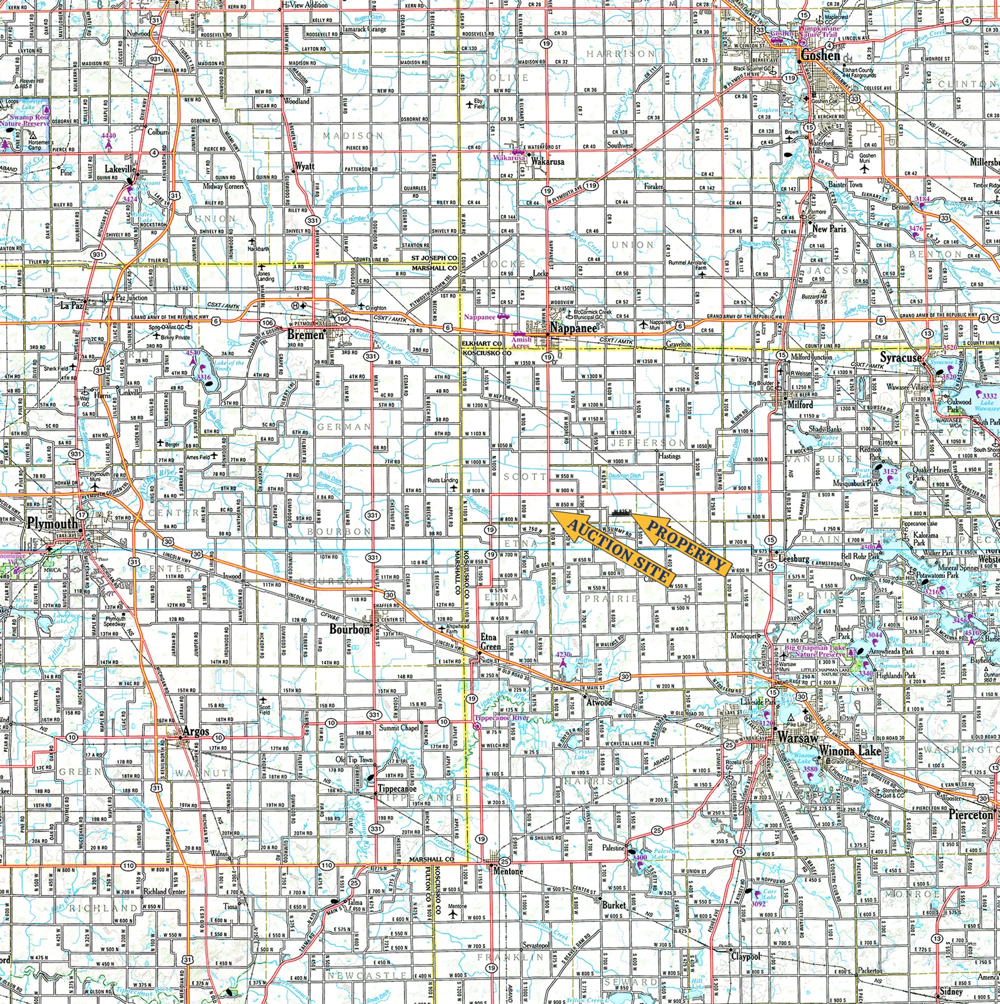
On W 825 N, Leesburg, IN 46538
Take SR 19 south out of Nappanee for 4 mi., then turn left onto CR 900 N. Continue on for 2 mi., then turn right onto CR 625 W. Continue for .5 mi. & turn left onto CR 850 N. Go around the corner onto CR 600 W & then turn left on to CR 825 N. The property will start on your left in .2 mi.. OR Take SR 15 north out of Leesburg for 2 mi., then turn left onto CR 900 N. Continue for 4.25 mi. & turn left onto CR 425 W. Continue for 1 mi., turn right onto CR 800 N. Continue 1.25 mi. & go around the corner. Property will start on the right of CR 825 N.
Auction location
Mt. Tabor Church of God Fellowship Hall,
8424 N 800 W, Etna Green, IN 46524
Property description
47.5+/- acres of level farm land w/ large amount of road
frontage.
Tract descriptions
| Tract | Acres | Description |
|---|---|---|
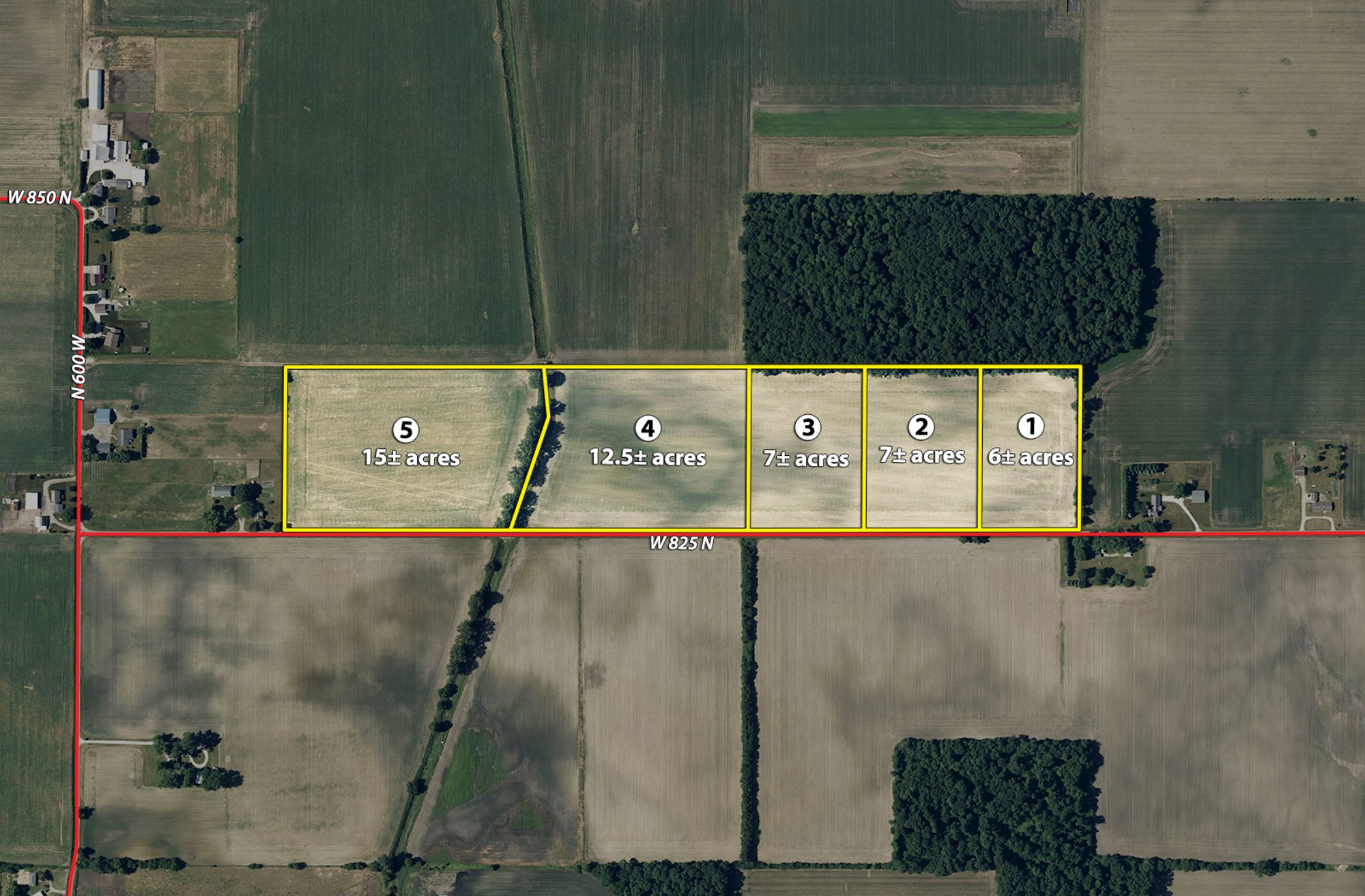
| 1 | 6± | all tillable cropland w/ approximately 395' of road frontage on 825 N. Soils are mixture of Homer sandy loam & Sebewa loam. |
| 2 | 7± | all tillable cropland w/ approximately 460' of road frontage on 825 N. Soils are mainly Homer sandy loam w/ some Sebewa loam. |
| 3 | 7± | nearly all tillable cropland w/ approximately 460' of road frontage on 825 N. Soils are a mixture of Sebewa loam, Bronson sandy loam, Brady sandy loam & Homer sandy loam. |
| 4 | 12.5± | of mostly tillable cropland w/ approximately 940' of road frontage on 825 N. West edge of property boarders open ditch. Soils are mixture of Sebewa loam, Sebewa mucky loam, Gilford sandy loam & Bronson sandy loam. |
| 5 | 15± | of mostly tillable cropland w/ approximately 890' of road frontage on 825 N. East edge of property boarders open ditch. Soils are mainly Bronson sandy loam & Ormas loamy sand |
Interactive map
Tract map
Area map
Terms
TERMS & CONDITIONS:
PROCEDURE: The property will be offered in 5 individual tracts, any combination of tracts & as a total 47.5+/- acre unit. There will be open bidding on all tracts & combinations during the auction as determined by the Auctioneer. The auction will be offered in individual tracts, combinations of tracts & as a whole.
DOWN PAYMENT: 10% down payment on the day of auction for individual tracts or combinations of tracts. The down payment may be made in the form of cashier's check, personal check or corporate check. YOUR BIDDING IS NOT CONDITIONAL UPON FINANCING, so be sure you have arranged financing, if needed, & are capable of paying cash at closing.
ACCEPTANCE OF BID PRICES: All successful bidders will be required to enter into Purchase Agreements at the auction site immediately following the close of the auction. All final bid prices are subject to the Sellers' acceptance or rejection.
EVIDENCE OF TITLE: Seller shall provide an owner's title insurance policy in the amount of the purchase price.
DEED: Seller shall provide Warranty Deed(s).
CLOSING: The targeted closing date will be approximately 45 days after the auction.
POSSESSION: Possession is at closing.
REAL ESTATE TAXES: Real estate taxes will be the responsibility of the Buyer(s) beginning w/ taxes due in 2026 & thereafter.
PROPERTY INSPECTION: Each potential Bidder is responsible for conducting, at their own risk, their own independent inspections, investigations, inquiries & due diligence concerning the property. Inspection dates have been scheduled & will be staffed w/ auction personnel. Further, Seller disclaims any & all responsibility for Bidder's safety during any physical inspection of the property. No party shall be deemed an invitee of the property by virtue of the offering of the property for sale.
ACREAGE: All tract acreages, dimensions & proposed boundaries are approximate & have been estimated based on current legal descriptions and/or aerial photos.
SURVEY: The Seller shall provide a new survey where there is no existing legal description or where new boundaries are created by the tract divisions in this auction. Any need for a new survey shall be determined solely by the Seller. Seller & successful bidder shall each pay half (50:50) of the cost of the survey. The type of survey performed shall be at the Seller's option & sufficient for providing title insurance. Combination purchases will receive a perimeter survey only.
AGENCY: Schrader Real Estate & Auction Company, Inc. & its representatives are exclusive agents of the Seller.
DISCLAIMER & ABSENCE OF WARRANTIES: All information contained in this brochure & all related materials are subject to the terms & conditions outlined in the Purchase Agreement. The property is being sold on an "AS IS, WHERE IS" basis, & no warranty or representation, either expressed or implied, concerning the property is made by the Seller or the Auction Company. All sketches & dimensions in the brochure are approximate. Each potential bidder is responsible for conducting his or her own independent inspections, investigations, inquiries & due diligence concerning the property. The information contained in this brochure is subject to verification by all parties relying on it. No liability for its accuracy, errors or omissions is assumed by the Seller or the Auction Company. Conduct of the auction & increments of bidding are at the direction & discretion of the Auctioneer. The Seller & Selling Agents reserve the right to preclude any person from bidding if there is any question as to the person's credentials, fitness, etc. All decisions of the Auctioneer are final. ANY ANNOUNCEMENTS MADE THE DAY OF THE SALE TAKE PRECEDENCE OVER PRINTED MATERIAL OR ANY OTHER ORAL STATEMENTS MADE.
Documents & downloads
Photos


