


• Highly Productive Cropland • Excellent Investment Opportunity • Ohio River Markets • Timberland • Potential Building Sites • Near South Spencer High School • Public Water Available
641 Acres Offered in 16 Tracts - 545 Cropland Acres
Just West of Rockport, Indiana - Spencer County
Owner: Stallings Family Wed, Jun 29, 2011 EASTERNAUCTION IS OVER
OPEN HOUSE/INSPECTION DATES
Monday, June 13 from 4:00-6:00 PM
Meet a Schrader Representative at Tract 2. Contact Auction Company for Private Showing.
PROPERTY LOCATION
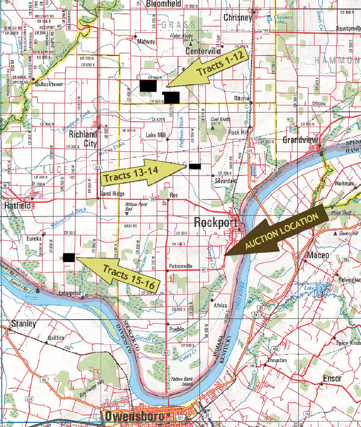
Tracts 1 - 12: From Rockport take St. Hwy. 66 west 3.1 miles to Orchard Road (beside South Spencer High School), turn north 4.5 miles to Tracts 1-8. For Tracts 9-12 continue on Orchard Road 1 mile to Co. Rd. 600N, turn west .8 mile to Tracts 9-12. Tracts 13 - 14: From Rockport take St. Hwy. 66 2.4 miles to Co. Rd. 200W, turn north 1.5 miles to Tracts 13-14. Tracts 15 - 16: From Rockport take St. Hwy. 66 west 7.6 miles to Co. Rd. 700W, turn south 1.5 miles to Eureka Road, turn west .5 mile to Co. Rd. 750W, turn south 1 mile to Tracts 15-16.
AUCTION LOCATION
American Legion in Rockport Indiana. Directions: From Rockport Indiana take State Hwy 45 south 1.5 miles to the American Legion on the right side of the Hwy. GPS Coordinates: 37 51 41 N / 87 06 17 W
PROPERTY DESCRIPTION
FSA Information
Tracts 1 - 8 & Tracts 13 & 14:
Cropland 254.4 Acres
2011 Direct Payment $4445.00
Corn Base 109.2 Ac.
Soybean Base 94.1 Ac.
Wheat Base 47.9 Ac. Tracts 9 - 12:
Cropland 183.8
2011 Direct Payment $3266.00
Corn Base 58.8 Ac.
Soybean Base 122.6 Ac.
Wheat Base 57.1 Ac. Tracts 15 & 16:
Cropland 106.3
2011 Direct Payment $1937.00
Corn Base 85.2 Ac.
Soybean Base 26.9 Ac.
Wheat Base 11.1 Ac.
TRACT DESCRIPTIONS
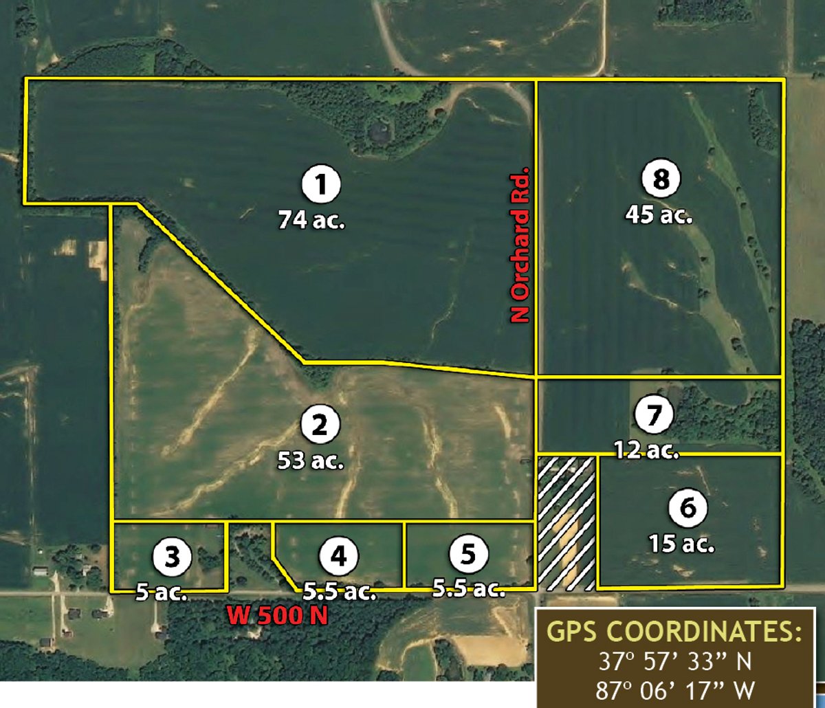
Tract 1: 74± ac productive cropland with frontage on Orchard Road.
Tract 2: 53± ac nearly all productive cropland adjoining Tract 1 and fronting Orchard Road.
Tract 3: 5± ac a potential building site, fronting Co. Rd. 500N, adjoining Tract 2.
Tract 4: 5.5± ac a potential building site with good elevation and frontage along Co. Rd. 500N.
Tract 5: 5.5± ac a potential building site at the corner of Orchard and Co. Rd. 500N.
Tract 6: 15± ac of productive cropland, fronting Co. Rd. 500N.
Tract 7: 12± ac situated between Tracts 6 & 8. This would be a good building site with a pond or combine with the adjoining tracts for a larger cropland parcel.
Tract 8: 45± ac nearly all cropland, fronting Orchard Road.
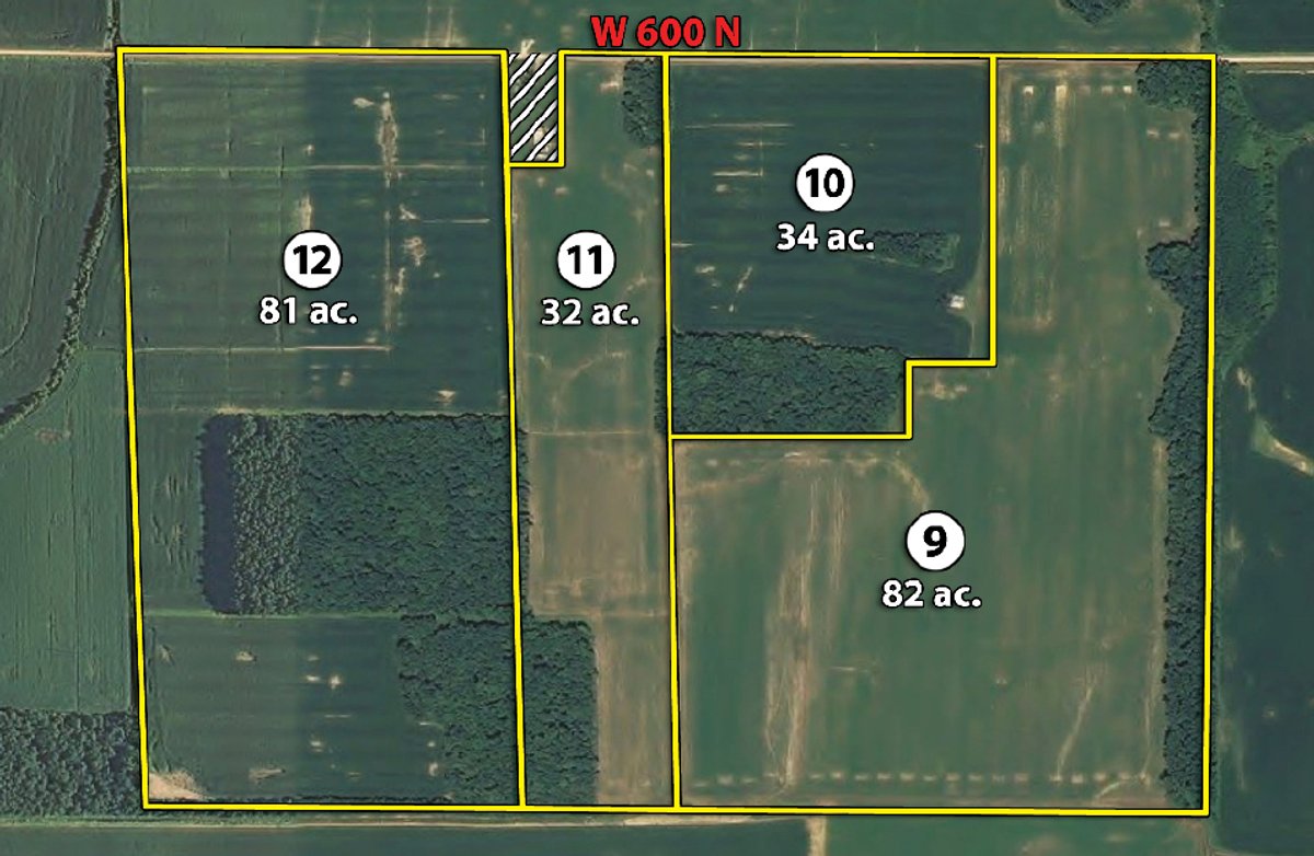
Tract 9: 82± ac nearly all cropland, fronting Co. Rd. 600N.
Tract 10: 34± ac mostly cropland with approximately 4 acres of woods, fronting Co. Rd. 600N.
Tract 11: 32± ac mostly cropland with some woods, fronting Co. Rd. 600N.
Tract 12: 81± ac mostly cropland with some wooded acres suitable for hunting and recreation, fronting Co. Rd. 600N.
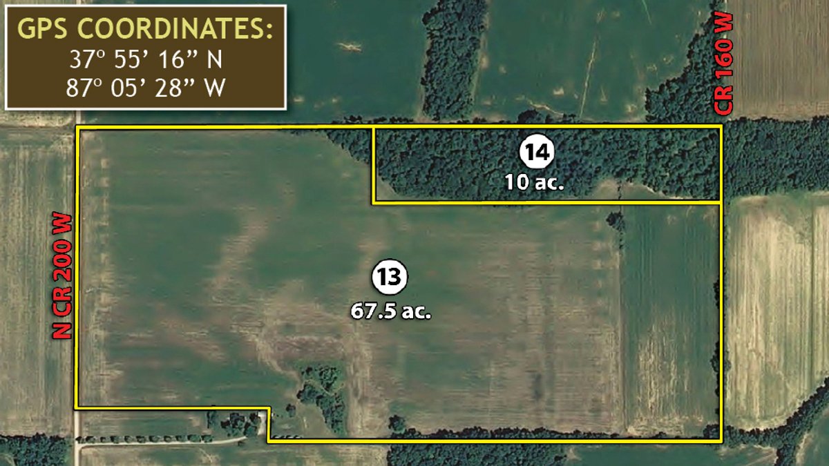
Tract 13: 67.5± ac mostly all cropland fronting Co. Rd. 200W, improved with four steel grain bins with perforated floors and aeration.
Tract 14: 10± ac all wooded with good elevation. A good recreational tract with building site potential.
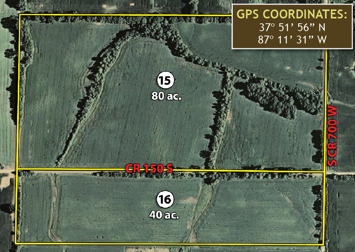
Tract 15: 80± ac nearly all cropland with county road frontage on three sides and sloping topography.
Tract 16: 40± ac nearly all cropland with lots of county road frontage and sloping topography.
AREA MAP
TRACT MAP(S)
AREA MAP(S)
PROCEDURE: Tracts 1 thru 16 will be offered in individual tracts, in any combination of these 16 tracts, or as a total unit. There will be open bidding on all tracts and combinations during the auction as determined by the auctioneer. Bids on tract, tract combinations, and total property may compete. The property will be sold in the manner resulting in the highest total sale price. DOWN PAYMENT: 10% of the Contract Purchase Price as down payment on the day of auction with the balance in cash at closing. YOUR BIDDING IS NOT CONDITIONAL UPON FINANCING, so be sure you have arranged financing, if needed, and are capable of paying cash at closing.
APPROVAL OF BID PRICES: The successful bidder will be required to enter into a Purchase Agreement at the auction site immediately following the close of the auction. All auction bids are subject to the acceptance or rejection by the Seller. DEED: Seller will convey by Warranty Deed.
EVIDENCE OF TITLE: The Owner agrees to furnish at Owners expense a Title Insurance Policy. A preliminary commitment will be available for review prior to the auction.
CLOSING: The closing shall take place 30 days after the auction day, or as soon thereafter as applicable closing documents are completed by Seller.
POSSESSION: Possession is at closing, subject to tenants rights.
Mineral Rights: Seller shall convey 75% of their mineral rights at the time of closing. Seller shall retain the remaining 25% of mineral rights through 2025 at which time that portion shall be conveyed to the surface owner.
Cash Credits to Buyer: The Sellers at the time of closing shall credit to the Buyer $150.00 per cropland acre based on current Farm Service Agency (FSA) records.
Real Estate Taxes: Seller shall pay the 2011 real estate taxes through the first installment due and payable in May of 2012. All subsequent taxes shall be the Buyers responsibility.
ACREAGE AND SURVEY: The Seller shall determine whether to convey title by current legal description or to survey the property. Any need for a new survey shall be at the Sellers sole discretion. Seller and Buyer shall each pay half (50:50) of the survey cost. The type of survey performed shall be at the Sellers option and sufficient for providing merchantable title. Closing prices shall be adjusted to reflect any difference between advertised and surveyed acres.
PROPERTY INSPECTION: Each potential Bidder is responsible for conducting, at their own risk, their own independent inspections, investigations, inquiries and due diligence concerning the property. An inspection date has been scheduled and will be staffed with auction personnel. Further, Seller disclaims any and all responsibility for Bidders safety during any physical inspection of the property.
AGENCY: Schrader Real Estate & Auction Company, Inc. and its representatives are exclusive agents of the Seller. There shall be no subagency.
DISCLAIMER AND ABSENCE OF WARRANTIES: All information contained in this brochure and all related materials are subject to the terms and conditions outlined in the Purchase Agreement. The property is being sold on an AS IS, WHERE IS basis, and no warranty or representation, either expressed or implied, concerning the property is made by the Seller or the Auction Company. All sketches and dimensions in the brochure are approximate. Each potential bidder is responsible for conducting his or her own independent inspections, investigations, inquiries, and due diligence concerning the property. The information contained in this brochure is subject to verification by all parties relying on it. No liability for its accuracy, errors, or omissions is assumed by the Seller or the Auction Company. Conduct of the auction and increments of bidding are at the direction and discretion of the Auctioneer. The Seller and Selling Agents reserve the right to preclude any person from bidding if there is any question as to the persons credentials, fitness, etc. All decisions of the Auctioneer are final. ANY ANNOUNCEMENTS MADE THE DAY OF THE SALE TAKE PRECEDENCE OVER PRINTED MATERIAL OR ANY OTHER ORAL STATEMENTS MADE.
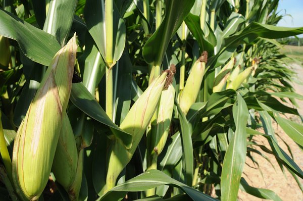
Stock Photography: Some photos of crops and cropland were used for illustrative purposes only.
None at this time


