


• 4,810+/- Acres Offered in 85 Tracts • Ranging from 2+/- to 617+/- Acres • 2,500+/- Productive Tillable Acres • Wooded Recreational Land • Prime Hunting and Wildlife • Franklin, Williamson, Hamilton & Saline Counties • Online Bidding Available • ADDITIONAL TRACTS WITHDRAWN FROM AUCTION: 55, 60, 61, 62 & 73

ILLINOIS LAND AUCTION - 4,810+/- ACRES OFFERED IN 85 TRACTS IN FRANKLIN, WILLIAMSON, HAMILTON & SALINE COUNTIES, ILLINOIS
Franklin, Williamson, Hamilton & Saline Counties, Illinois
Wed, Oct 17, 2018 EASTERNAUCTION IS OVER
TOTAL SOLD: $13,056,280
| Tract(s): 1 | @ $236,900 | ($5,778/acre) |
| Tract(s): 2 | @ $581,950 | ($5,300/acre) |
| Tract(s): 3 | @ $875,500 | ($5,159/acre) |
| Tract(s): 4 | @ $684,950 | ($3,863/acre) |
| Tract(s): 5 | @ $375,950 | ($3,069/acre) |
| Tract(s): 6 | @ $10,300 | ($5,150/acre) |
| Tract(s): 7+68-70+79 | @ $580,920 | ($1,882/acre) |
| Tract(s): 8+9 | @ $164,800 | ($3,924/acre) |
| Tract(s): 10 | @ $185,400 | ($4,635/acre) |
| Tract(s): 11-14 | @ $427,450 | ($2,865/acre) |
| Tract(s): 15 | @ $164,800 | ($1,677/acre) |
| Tract(s): 16 | @ $164,800 | ($3,469/acre) |
| Tract(s): 17 | @ $252,350 | ($1,823/acre) |
| Tract(s): 18+20 | @ $1,084,590 | ($3,483/acre) |
| Tract(s): 19 | @ $309,000 | ($3,911/acre) |
| Tract(s): 21+22+24+41+42+88+89 | @ $2,250,550 | ($3,281/acre) |
| Tract(s): 23+40+86 | @ $236,199 | ($1,914/acre) |
| Tract(s): 25+34 | @ $36,050 | ($1,321/acre) |
| Tract(s): 26+27 | @ $216,300 | ($1,626/acre) |
| Tract(s): 28 | @ $26,780 | ($2,678/acre) |
| Tract(s): 33 | @ $7,210 | ($1,602/acre) |
| Tract(s): 35+36+38+39 | @ $268,501 | ($1,738/acre) |
| Tract(s): 37+72 | @ $118,450 | ($2,154/acre) |
| Tract(s): 43-45 | @ $80,340 | ($1,101/acre) |
| Tract(s): 46 | @ $66,950 | ($1,231/acre) |
| Tract(s): 47-49+53+54 | @ $123,600 | ($1,984/acre) |
| Tract(s): 50+58+59 | @ $516,030 | ($2,315/acre) |
| Tract(s): 51+52+64 | @ $339,900 | ($2,925/acre) |
| Tract(s): 56+57 | @ $128,750 | ($4,486/acre) |
| Tract(s): 63 | @ $35,020 | ($1,751/acre) |
| Tract(s): 65 | @ $30,900 | ($3,090/acre) |
| Tract(s): 67 | @ $65,920 | ($2,126/acre) |
| Tract(s): 71 | @ $48,410 | ($2,548/acre) |
| Tract(s): 74 | @ $77,250 | ($3,511/acre) |
| Tract(s): 75+76 | @ $154,500 | ($1,896/acre) |
| Tract(s): 77+78 | @ $187,460 | ($1,802/acre) |
| Tract(s): 80 | @ $133,900 | ($3,348/acre) |
| Tract(s): 81 | @ $76,220 | ($2,541/acre) |
| Tract(s): 82 | @ $339,900 | ($4,249/acre) |
| Tract(s): 83 | @ $86,520 | ($2,163/acre) |
| Tract(s): 84 | @ $515,000 | ($8,729/acre) |
| Tract(s): 85 | @ $515,000 | ($3,219/acre) |
| Tract(s): 87 | @ $275,010 | ($2,449/acre) |
OPEN HOUSE/INSPECTION DATES
Wednesday, September 5 from 3-6pm
Thursday, September 6 from 9-12 Noon
Friday, September 28 from 3-6pm
Saturday, September 29 from 9-12 Noon
Monday, October 8 from 3-6pm
Tuesday, October 9 from 9-12 Noon
Tuesday, October 16 from 9-12 Noon
Meet a Schrader Representative at the Holiday Inn Express, 2609 Blue Heron Dr. Marion IL 62959 for more information.
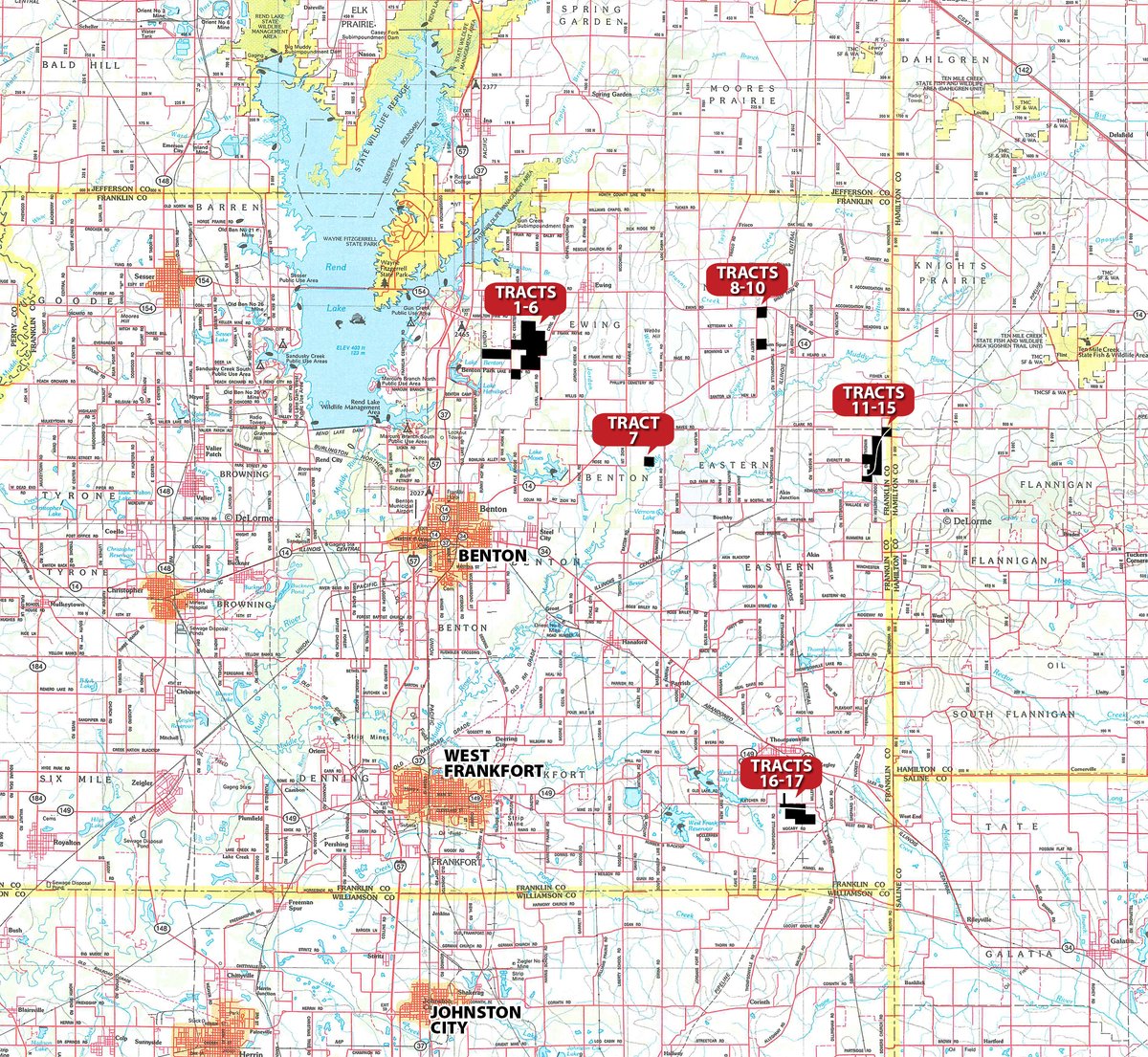
PROPERTY LOCATION
FRANKLIN COUNTY
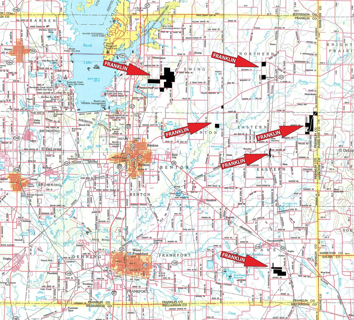
Tracts 1-6: From the jct of IL Hwy. 37 and Hwy. 34 in downtown Benton IL take Hwy. 37 north approx 4.4 miles to Lake Benton Rd, turn east 2.5 miles to tracts 1-6.
Tract 7: From the NE side of Benton IL take IL Hwy. 14 (Bailey Ln) east 4.5 miles to Mt Zion Rd turn south 7/10 miles to an easement access point turn east 1/2 mile to the NW corner of Tract 7.
Tracts 8-10: From the NE side of Benton IL take IL Hwy. 14 east approx 8.5 miles to Liberty Rd turn north 1 mile to tracts 8-9, or turn north 3/10 mile to tract 10.
Tracts 11-15: From the NE side of Benton IL take IL Hwy. 14 east approx 9 miles to Thompsonville RD turn south 1.9 miles to Clark Rd, turn East 2.9 miles to tract 11-15.
Tracts 16-17: From Benton IL take IL Hwy. 34 SE 10 miles to Thompsonville IL, turn south on Main St (Coubty Hwy. 10) and travel 1.5 miles to tracts 16-17.
WILLIAMSON COUNTY
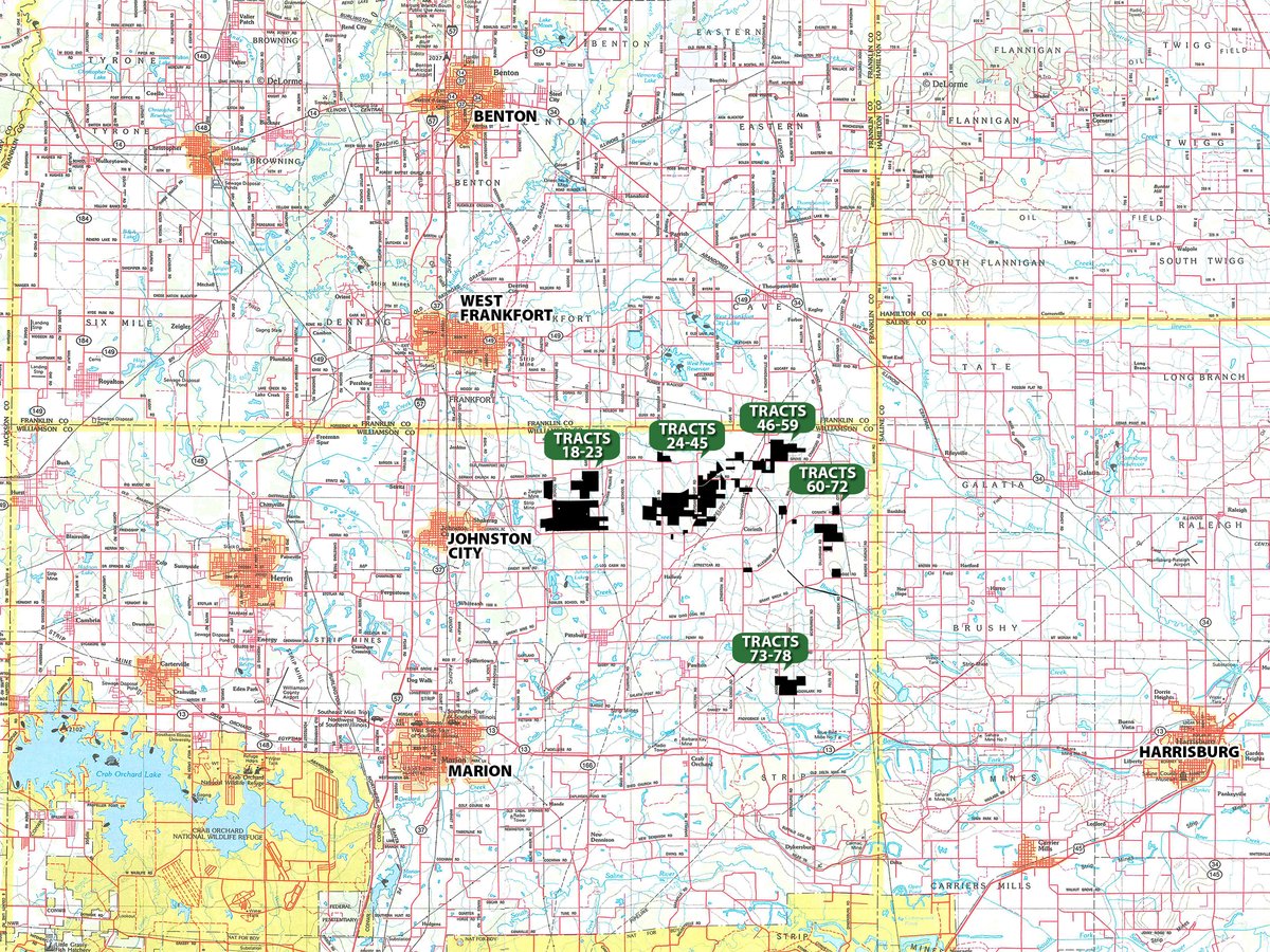
Tracts 18-72: From I-57 exit 59 at Johnston City IL travel east on Broadway St (Corinth Rd) and then as below:
Tracts 18-23: Travel 4.2 miles to Harris School Rd turn north 2/10 to the property.
Tracts 24-45: Travel 7.2 miles to Dwina Rd turn north 1/2 mile or continue 1 mile to Jordans Fort Rd turn north 1/2 mile to the property.
Tracts 46-59: Travel 12 miles through Corinth (watch for auction signs) to Dillinghan Rd, turn south to tract 68-72.
Tracts 60-72: Travel 12 miles on Corinth Rd through Corinth watch for signs to tracts 64-66. Continue approx 1 1/2 mile to tract 67.
Tracts 68-72: Travel approximately 13 miles on Corinth Rd to Dillingham Rd turn south watch for signs and refer to the brochure mapping.
Tracts 73-78: From the jct of IL Hwy. 37 & Hwy. 13 at Marion IL, take Hwy. 13 east 10 miles to Angelville Rd turn north 1.8 miles to tract 74-78.
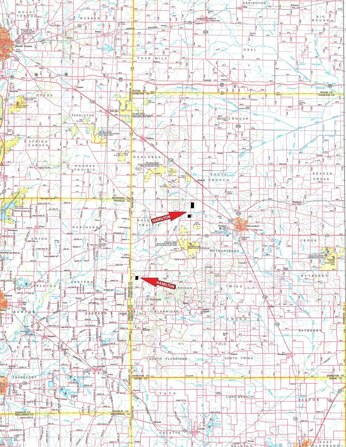
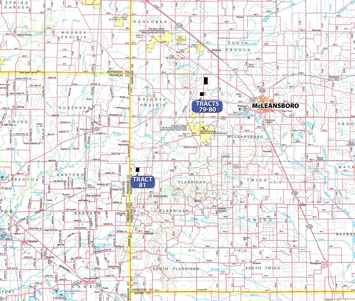
HAMILTON COUNTY
Tract 79: From the westside of McLeansboro IL take IL Hwy. 142 NW approx 4 miles to Co Rd 1500 N turn south and proceed 1 mile to tract 79.
Tract 80: From the westside of McLeansboro IL take IL Hwy. 142 NW approx 3.3 miles to Co Rd 600 E turn south 1.5 miles to Co Rd 1325 N turn west 3/10 mile to Co Rd 500 E turn N 3/10 to tract 80.
Tract 81: Refer to directions for tracts 11-15. Tract 81 is located 1 mile east of tracts 11-15 along Co Rd 850 N (watch for signs).
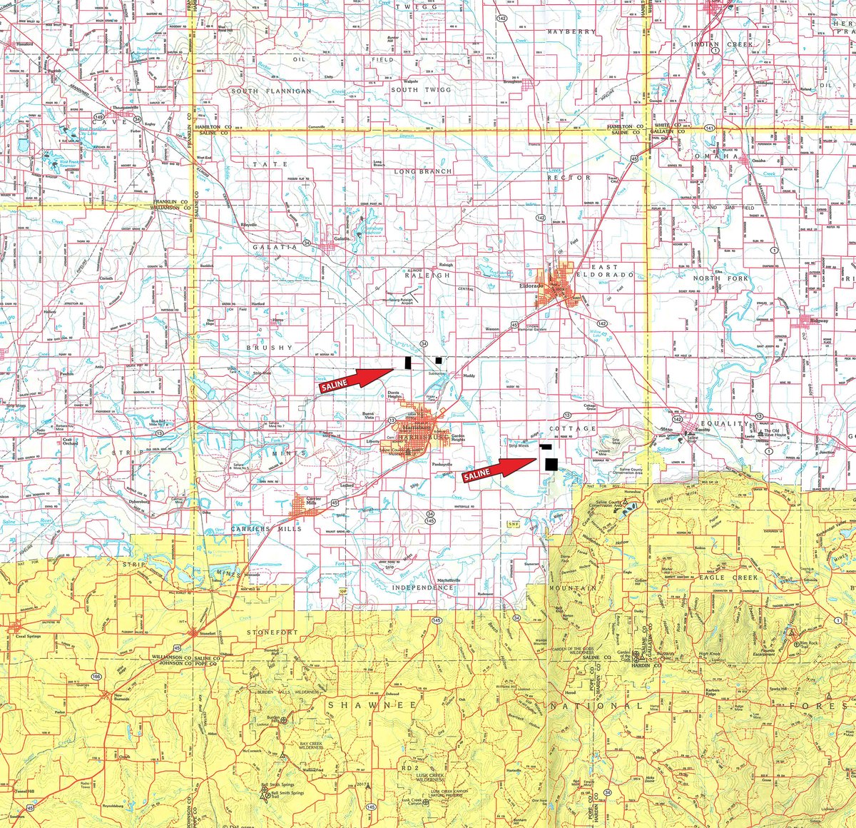
SALINE COUNTY
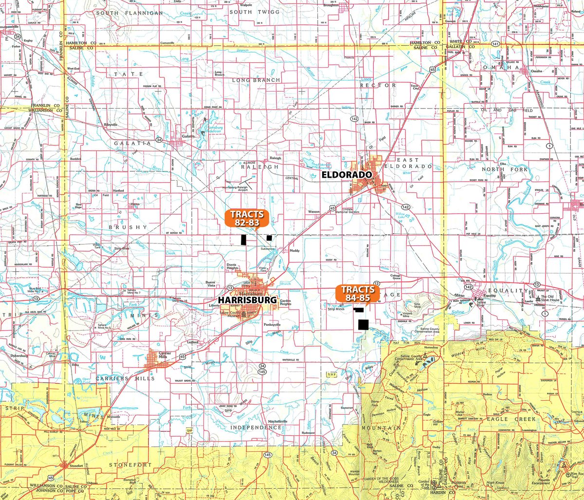
Tracts 82-83: From the jct of IL Hwy. 13 and Hwy. 34 at the northside of Harrisburg IL take Hwy. 34 north 2 miles to Mt Moriah Rd, turn west 1/2 mile to the property.
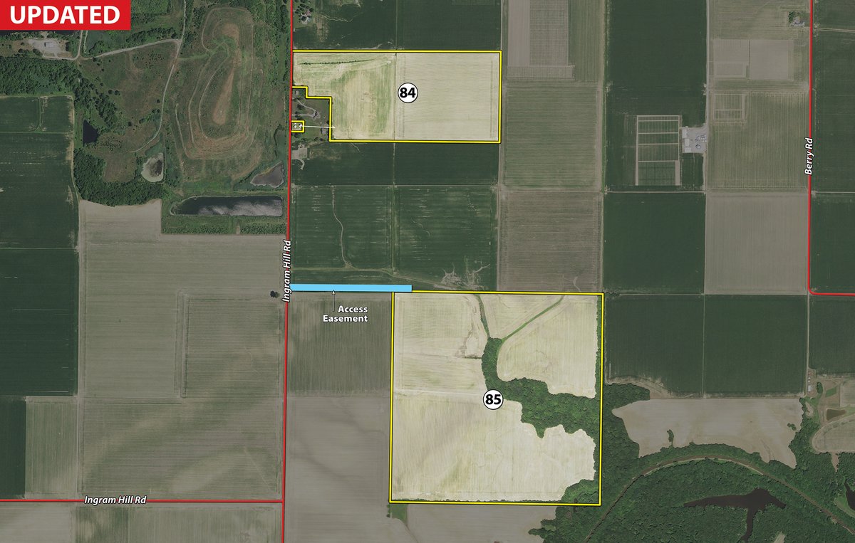
Tract 84-85: From the jct of IL Hwy. 45 and Hwy. 13 on the northeast side of Harrisburg IL take Hwy. 13 east 3.5 miles to Lindale Rd turn south 3/4 mile to Big Ridge Rd turn east 1/2 mile to Ingram Rd, turn south 3/10 mile to the property.
AUCTION LOCATION
The Pavilion, 1602 Sioux Drive, Marion, IL. From the junction of I-57 & State Hwy. 13 at Marion, IL, go west on Hwy. 13 0.7 mile to Williamson County Parkway, turn north 0.7 mile to Sioux Drive, turn right and proceed to The Pavilion.
PROPERTY DESCRIPTION
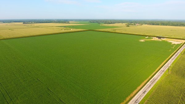
This auction represents a great opportunity to buy tillable and recreational land that has not been available for many years. In the Schrader method of auction, you can bid on any tract or combination of tracts that meet your needs.
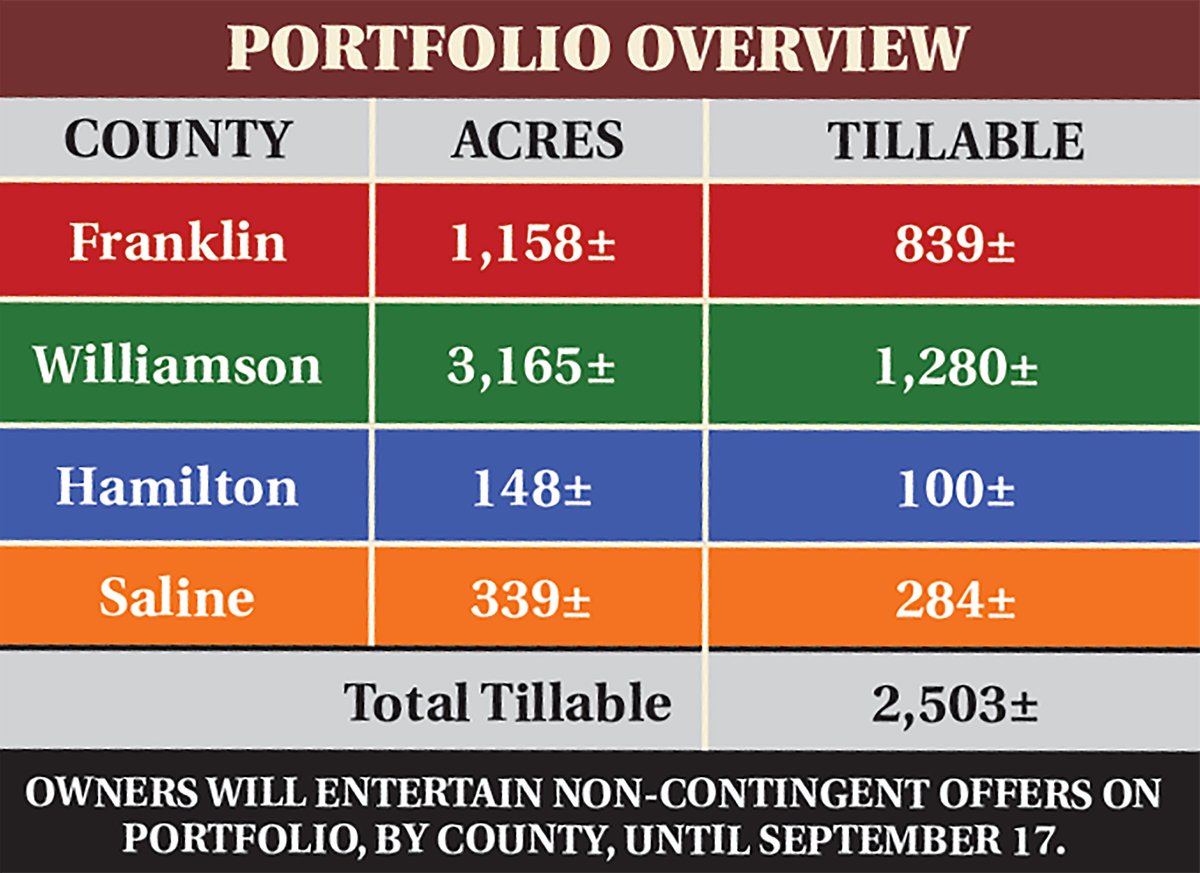
FRANKLIN COUNTY - 1,158+/- ACRES - 839+/- TILLABLE ACRES
WILLIAMSON COUNTY - 3,165+/- ACRES - 1,280+/- TILLABLE ACRES
HAMILTON COUNTY - 148+/- ACRES - 100+/- TILLABLE ACRES
SALINE COUNTY - 339+/- ACRES - 284+/- TILLABLE ACRES
TOTAL TILLABLE ACRES IS 2,503+/-
TRACT DESCRIPTIONS
Tract 1:
41± ac
FRANKLIN COUNTY
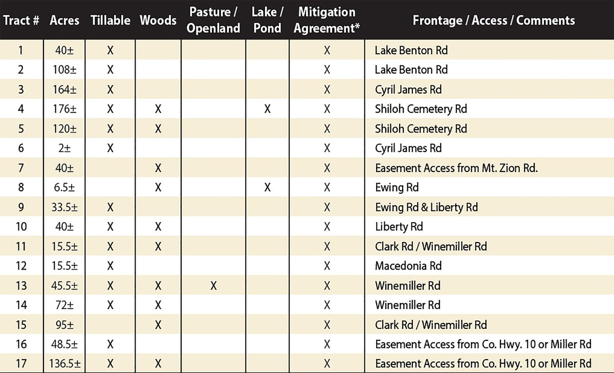
Tillable - Mitigation Agreement - Lake Benton Rd. Frontage/Access
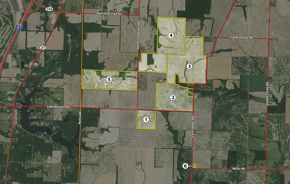
Tract 2: 109.8± ac Tillable - Mitigation Agreement - Lake Benton Rd. Frontage/Access
Tract 3: 169.7± ac Tillable - Mitigation Agreement - Cyril James Rd. Frontage/Access
Tract 4: 177.3± ac Tillable - Woods - Lake/Pond - Mitigation Agreement - Shiloh Cemetery Rd. Frontage/Access
Tract 5: 122.5± ac Tillable - Woods - Mitigation Agreement - Shiloh Cemetery Rd. Frontage/Access
Tract 6: 2± ac Tillable - Mitigation Agreement - Cyril James Rd. Frontage/Access
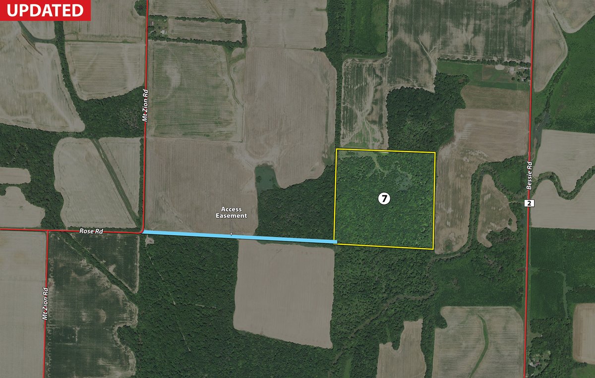
Tract 7: 40.7± ac Woods - Mitigation Agreement - Easement Access from Mt. Zion Rd.
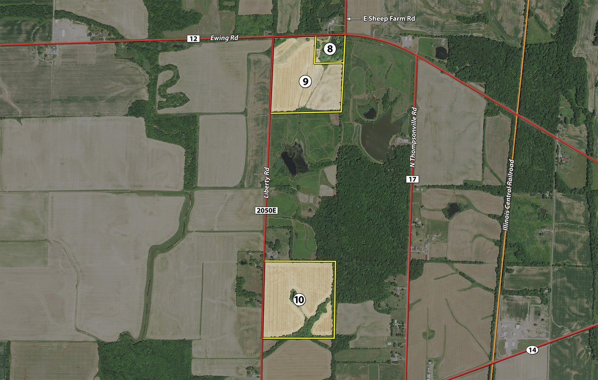
Tract 8: 6.5± ac Woods - Lake/Pond - Mitigation Agreement - Ewing Rd. Frontage/Access
Tract 9: 35.5± ac Tillable - Mitigation Agreement - Ewing Rd. & Liberty Rd. Frontage/Access
Tract 10: 40± ac Tillable - Woods - Mitigation Agreement - Liberty Rd. Frontage/Access
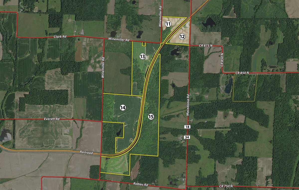
Tract 11: 15.4± ac Tillable - Woods - Mitigation Agreement - Clark Rd. & Winemiller Rd. Frontage/Access
Tract 12: 15.7± ac Tillable - Mitigation Agreement - Macedonia Rd. Frontage/Access
Tract 13: 46.6± ac Tillable - Woods - Pasture/Openland - Mitigation Agreement - Winemiller Rd. Frontage/Access
Tract 14: 71.5± ac Tillable - Woods - Mitigation Agreement - Winemiller Rd. Frontage/Access
Tract 15: 98.3± ac Woods - Mitigation Agreement - Clark Rd. & Winemiller Rd. Frontage/Access
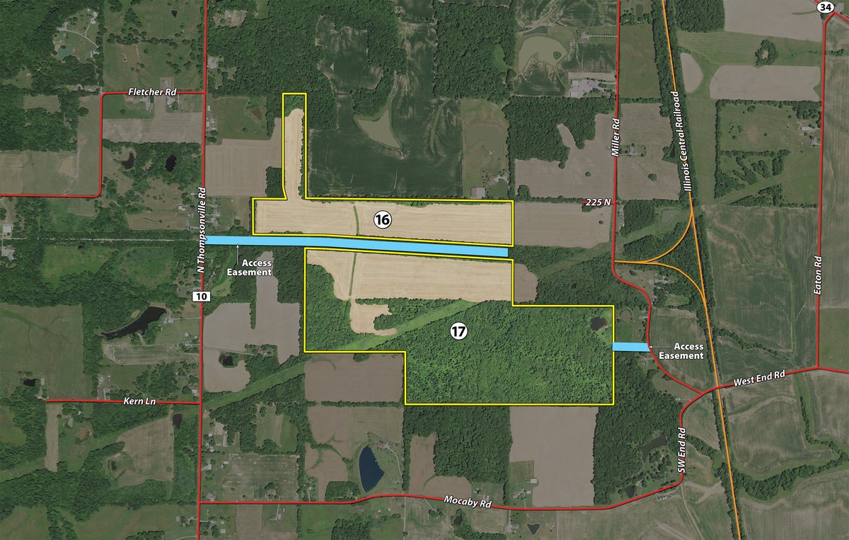
Tract 16: 47.5± ac Tillable - Mitigation Agreement - Easement Access from Co. Hwy. 10 or Miller Rd. Frontage/Access
Tract 17: 138.4± ac Tillable - Woods - Mitigation Agreement - Easement Access from Co. Hwy. 10 or Miller Rd. Frontage/Access
Tract 18:
71± ac
WILLIAMSON COUNTY
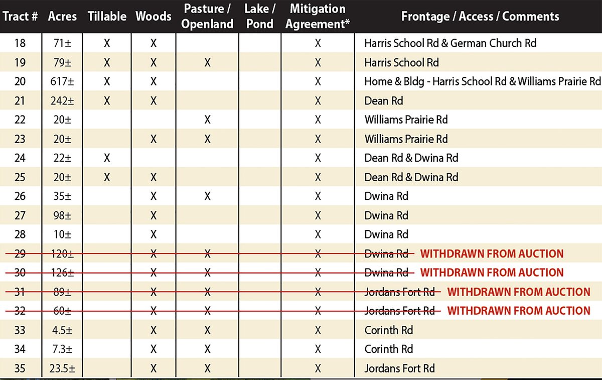
Tillable - Woods - Mitigation Agreement - Harris School Rd. & German Church Rd. Frontage/Access
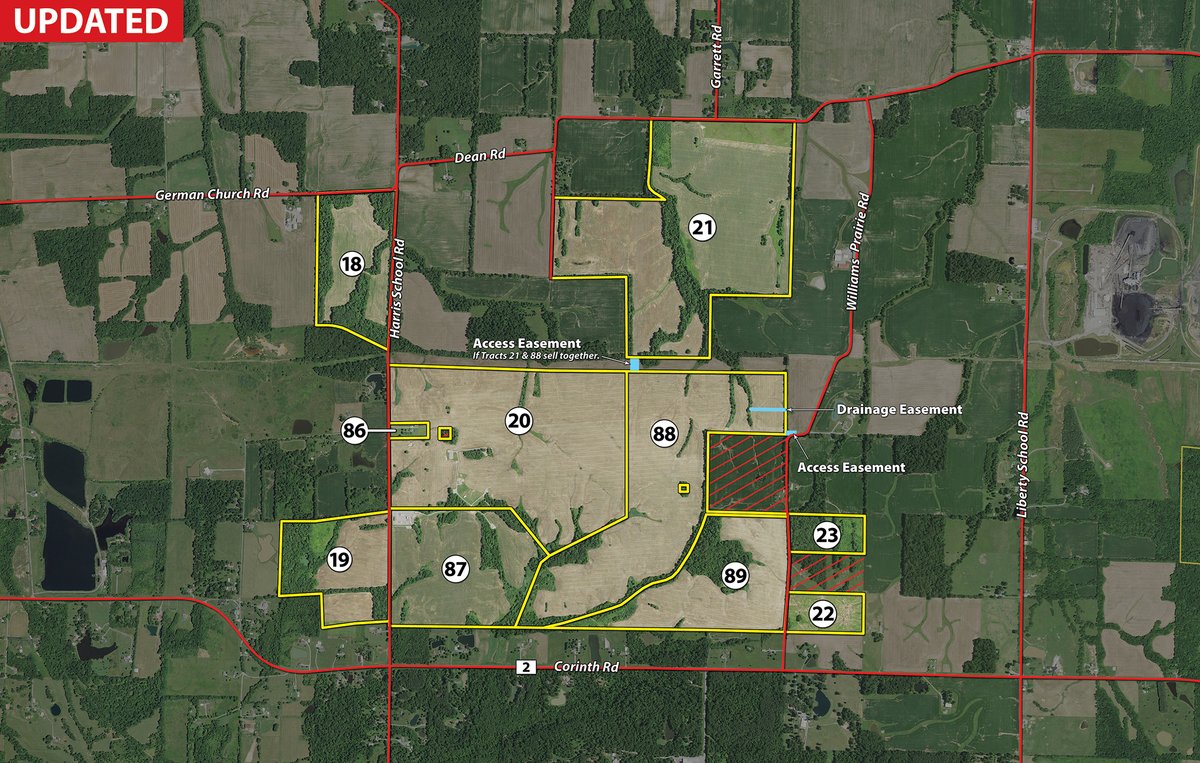
Tract 19: 79± ac Tillable - Woods - Pasture/Openland - Mitigation Agreement - Harris School Rd. Frontage/Access
Tract 20: 240.4± ac Tillable - Woods - Mitigation Agreement - Home & Bldg. - Harris School Rd. & Williams Prairie Rd. Frontage/Access
Tract 21: 253.7± ac Tillable - Woods - Mitigation Agreement - Dean Rd. Frontage/Access
Tract 22: 20± ac Pasture/Openland - Mitigation Agreement - Williams Prairie Rd. Frontage/Access
Tract 23: 22.4± ac Woods - Pasture/Openland - Mitigation Agreement - Williams Prairie Rd. Frontage/Access
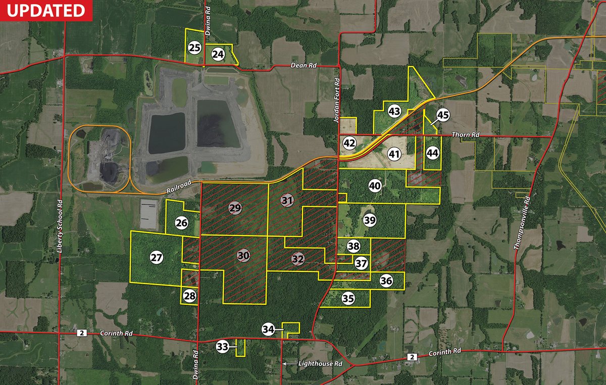
Tract 24: 22± ac Tillable - Mitigation Agreement - Dean Rd. & Dwina Rd. Frontage/Access
Tract 25: 20± ac Tillable - Woods - Mitigation Agreement - Dean Rd. & Dwina Rd. Frontage/Access
Tract 26: 35± ac Woods - Pasture/Openland - Mitigation Agreement - Dwina Rd. Frontage/Access
Tract 27: 98± ac Woods - Mitigation Agreement - Dwina Rd. Frontage/Access
Tract 28: 10± ac Woods - Mitigation Agreement - Dwina Rd. Frontage/Access
Tract 29:
Tract 30:
Tract 31:
Tract 32:
Tract 33: 4.5± ac Woods - Pasture/Openland - Mitigation Agreement - Corinth Rd. Frontage/Access
Tract 34: 7.3± ac Woods - Pasture/Openland - Mitigation Agreement - Corinth Rd. Frontage/Access
Tract 35: 23.5± ac Woods - Pasture/Openland - Mitigation Agreement - Jordans Fort Rd. Frontage/Access
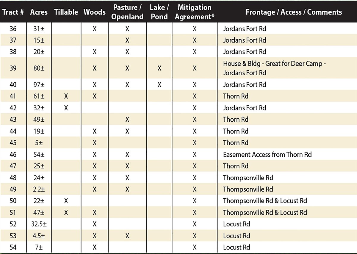
Tract 36: 31± ac Woods - Pasture/Openland - Mitigation Agreement - Jordans Fort Rd. Frontage/Access
Tract 37: 15± ac Pasture/Openland - Mitigation Agreement - Jordans Fort Rd. Frontage/Access
Tract 38: 20± ac Woods - Pasture/Openland - Mitigation Agreement - Jordans Fort Rd. Frontage/Access
Tract 39: 80± ac Woods - Pasture/Openland - Lake/Pond - Mitigation Agreement - House & Bldg. - Great for Deer Camp - Jordans Fort Rd. Frontage/Access
Tract 40: 97± ac Woods - Pasture/Openland - Lake/Pond - Mitigation Agreement - Jordans Fort Rd. Frontage/Access
Tract 41: 63.3± ac Tillable - Woods - Mitigation Agreement - Thorn Rd. Frontage/Access
Tract 42: 32± ac Tillable - Mitigation Agreement - Jordans Fort Rd. Frontage/Access
Tract 43: 49± ac Pasture/Openland - Mitigation Agreement - Thorn Rd. Frontage/Access
Tract 44: 19± ac Woods - Pasture/Openland - Mitigation Agreement - Thorn Rd. Frontage/Access
Tract 45: 5± ac Woods - Mitigation Agreement - Thorn Rd. Frontage/Access
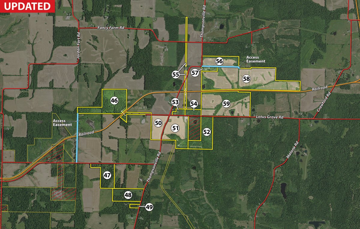
Tract 46: 54.4± ac Woods - Pasture/Openland - Mitigation Agreement - Easement Access from Thorn Rd. Frontage/Access
Tract 47: 25± ac Woods - Pasture/Openland - Mitigation Agreement - Thorn Rd. Frontage/Access
Tract 48: 24± ac Woods - Pasture/Openland - Mitigation Agreement - Thompsonville Rd. Frontage/Access
Tract 49: 2.2± ac Woods - Pasture/Openland - Mitigation Agreement - Thompsonville Rd. Frontage/Access
Tract 50: 21.6± ac Tillable - Mitigation Agreement - Thompsonville Rd. & Locust Rd. Frontage/Access
Tract 51: 45.7± ac Tillable - Woods - Mitigation Agreement - Thompsonville Rd. & Locust Rd. Frontage/Access
Tract 52: 33.5± ac Woods - Mitigation Agreement - Locust Rd. Frontage/Access
Tract 53: 4± ac Woods - Pasture/Openland - Mitigation Agreement - Locust Rd. Frontage/Access
Tract 54: 7.1± ac Woods - Mitigation Agreement - Locust Rd. Frontage/Access
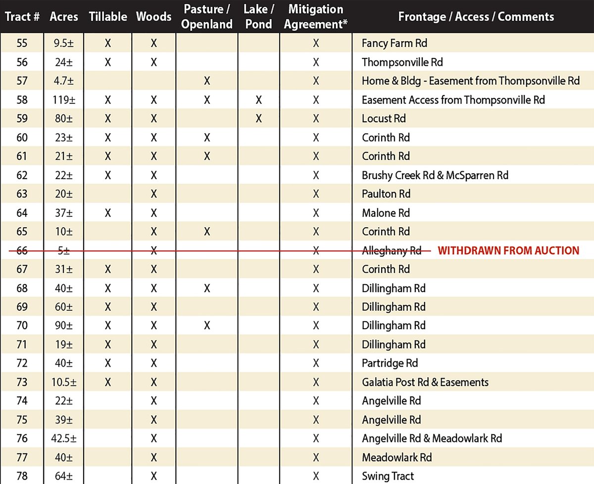
Tract 55: Tillable - Woods - Mitigation Agreement - Fancy Farm Rd. Frontage/Access
Tract 56: 24± ac Tillable - Woods - Mitigation Agreement - Thompsonville Rd. Frontage/Access
Tract 57: 4.7± ac Pasture/Openland - Mitigation Agreement - Home & Bldg. - Easement from Thompsonville Rd. Frontage/Access
Tract 58: 120.6± ac Tillable - Woods - Pasture/Openland -Lake/Pond - Mitigation Agreement - Home & Bldg. - Easement Access from Thompsonville Rd. Frontage/Access
Tract 59: 80.7± ac Tillable - Woods - Lake/Pond - Mitigation Agreement - Locust Rd. Frontage/Access
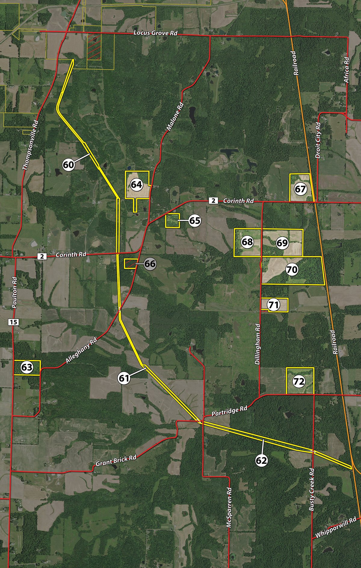
Tract 60: Tillable - Woods - Pasture/Openland - Mitigation Agreement - Corinth Rd. Frontage/Access
Tract 61: Tillable - Woods - Pasture/Openland - Mitigation Agreement - Corinth Rd. Frontage/Access
Tract 62: Tillable - Woods - Mitigation Agreement - Brushy Creek Rd & McSparren Rd. Frontage/Access
Tract 63: 20± ac Woods - Mitigation Agreement - Paulton Rd. Frontage/Access
Tract 64: 37± ac Tillable - Woods - Mitigation Agreement - Malone Rd. Frontage/Access
Tract 65: 10± ac Woods - Pasture/Openland - Mitigation Agreement - Corinth Rd. Frontage/Access
Tract 66:
Tract 67: 31± ac Tillable - Woods - Mitigation Agreement - Corinth Rd. Frontage/Access
Tract 68: 40± ac Tillable - Woods - Pasture/Openland - Mitigation Agreement - Dillingham Rd. Frontage/Access
Tract 69: 60± ac Tillable - Woods - Mitigation Agreement - Dillingham Rd. Frontage/Access
Tract 70: 90± ac Tillable - Woods - Pasture/Openland - Mitigation Agreement - Dillingham Rd. Frontage/Access
Tract 71: 19± ac Tillable - Woods - Mitigation Agreement - Dillingham Rd. Frontage/Access
Tract 72: 40± ac Tillable - Woods - Mitigation Agreement - Partridge Rd. Frontage/Access
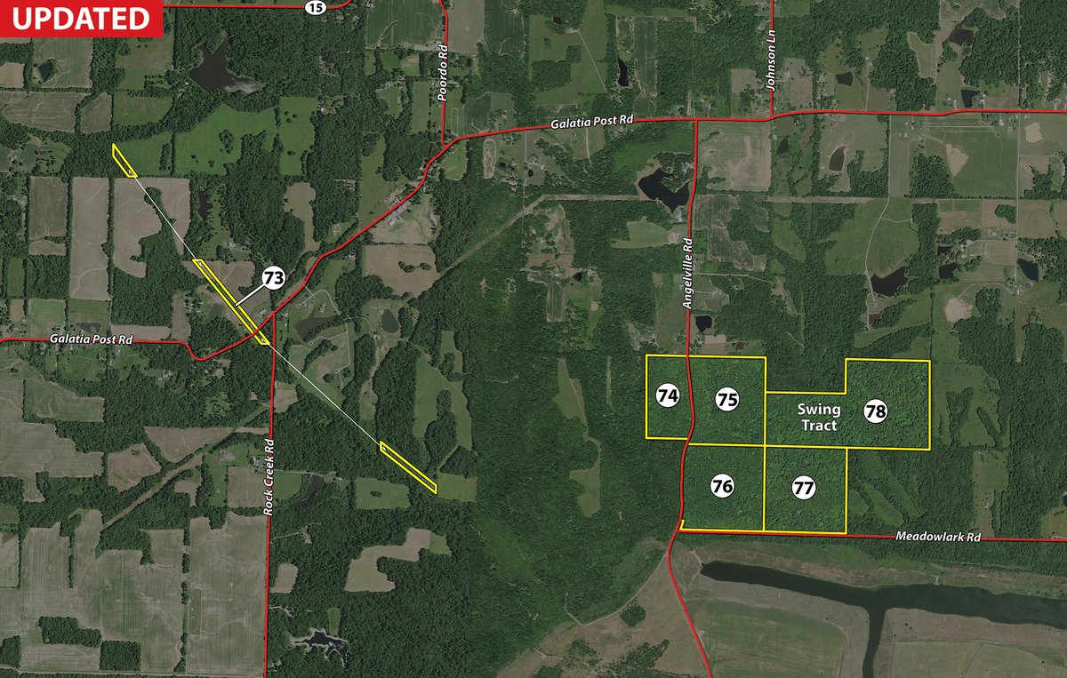
Tract 73: Tillable - Woods - Mitigation Agreement - Galatia Post Rd. & Easements Frontage/Access
Tract 74: 22± ac Woods - Mitigation Agreement - Angelville Rd. Frontage/Access
Tract 75: 39± ac Woods - Mitigation Agreement - Angelville Rd. Frontage/Access
Tract 76: 42.5± ac Woods - Mitigation Agreement - Angelville Rd. & Meadowlark Rd. Frontage/Access
Tract 77: 40± ac Woods - Mitigation Agreement - Meadowlark Rd. Frontage/Access
Tract 78: 64± ac Woods - Mitigation Agreement - SWING TRACT Frontage/Access
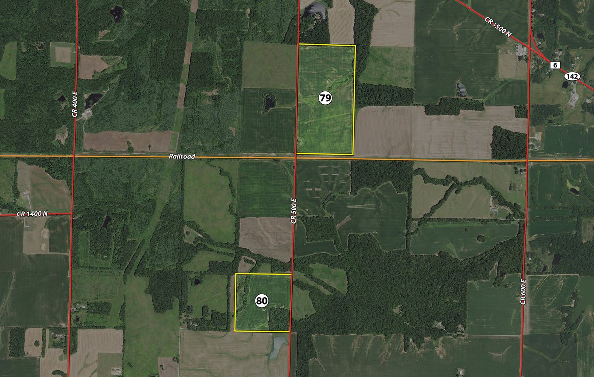
Tract 79:
78± ac
HAMILTON COUNTY
Tillable - Mitigation Agreement - Co Rd. 500 from Co Rd. 1500 N Rd. Frontage/Access
Tract 80: 40± ac Tillable - Woods - Mitigation Agreement - Co Rd. 500 from Co Rd. 1500 N Rd. Frontage/Access
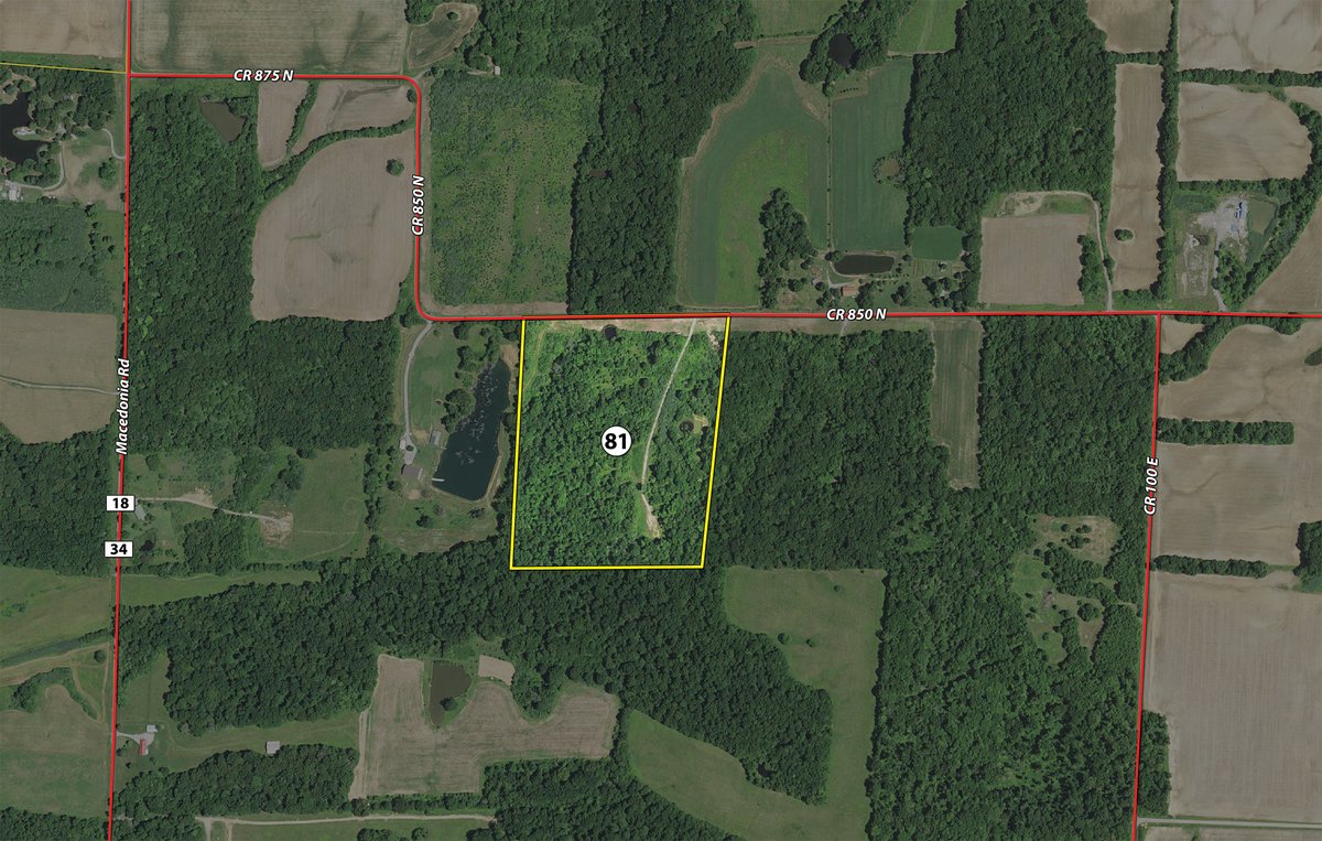
Tract 81: 30± ac Woods - Pasture/Openland - Mitigation Agreement - Co Rd. 850 N Frontage/Access
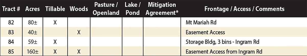
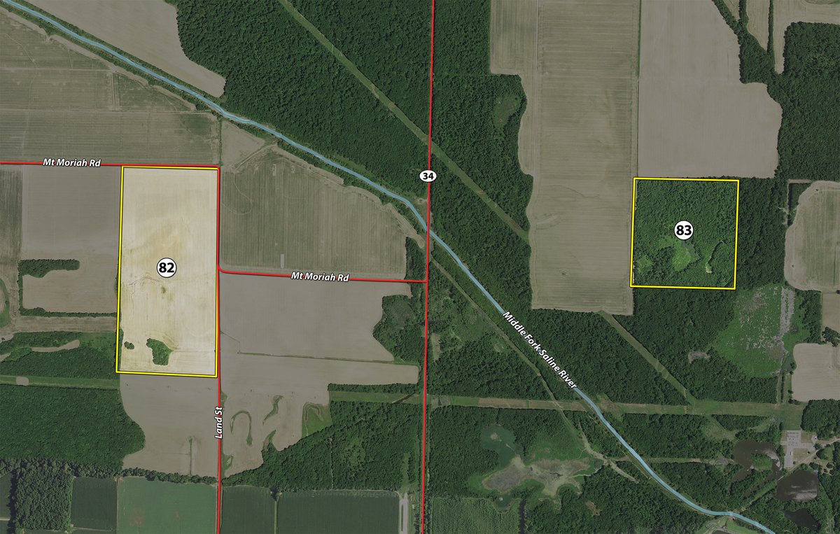
Tract 82:
80± ac
SALINE COUNTY
Tillable - Mt. Mariah Rd. Frontage/Access
Tract 83: 40± ac Woods - Easement Access Frontage/Access
Tract 84: 59± ac Tillable - Storage Bldg, 3 bins - Ingrim Rd. Frontage/Access
Tract 85: 160± ac Tillable - Woods - Easement Access from Ingrim Rd. Frontage/Access
Tract 86: 4± ac
Tract 87: 112.3± ac
Tract 88: 193.3± ac
Tract 89: 101.7± ac
TRACT MAP(S)
TRACTS 1-6
TRACT 7
TRACTS 8-10
TRACTS 11-15
TRACTS 16-17
TRACTS 18-23 & 86-89
TRACTS 24-45
TRACTS 46-59
TRACTS 60-72
TRACTS 73-78
TRACTS 79-80
TRACT 81
TRACTS 82-83
TRACTS 84-85
AREA MAP(S)
ALL COUNTIES
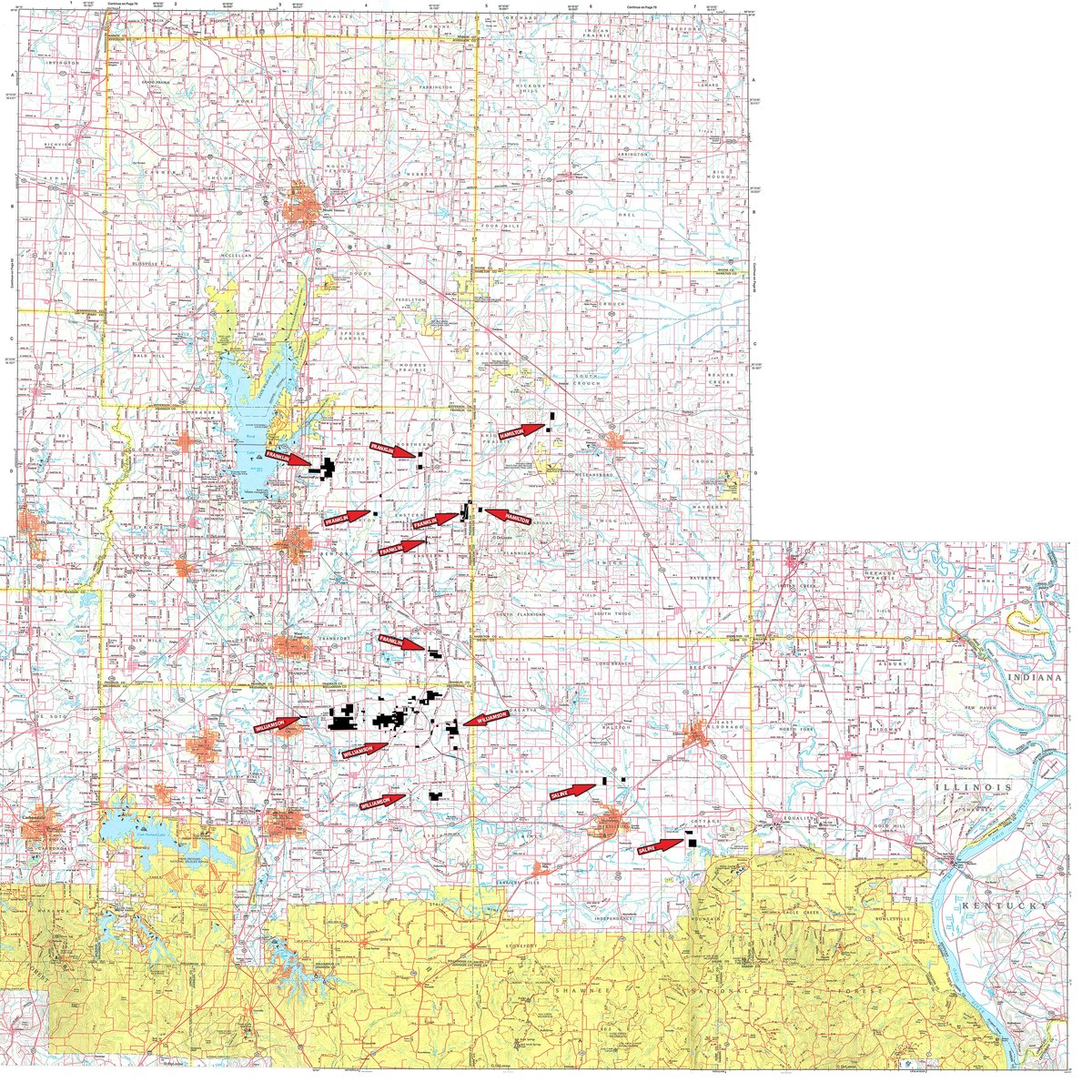
ALL COUNTIES
FRANKLIN COUNTY
FRANKLIN COUNTY
HAMILTON COUNTY
HAMILTON COUNTY
SALINE COUNTY
SALINE COUNTY
WILLIAMSON COUNTY
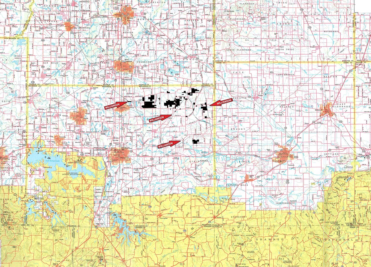
WILLIAMSON COUNTY
PROCEDURE: The property will be offered in 85 individual tracts, any combination of tracts and as a total unit. There will be open bidding on all tracts and combinations during the auction as determined by the Auctioneer. Bids on tracts, tract combinations and the total property may compete.
BUYERS PREMIUM: A 3% Buyers Premium will be added to the final bid price and included in the contract purchase price.
DOWN PAYMENT: 10% down payment on the day of auction for individual tracts or combinations of tracts. The down payment may be made in the form of cashiers check, personal check, or corporate check. YOUR BIDDING IS NOT CONDITIONAL UPON FINANCING, so be sure you have arranged financing, if needed, and are capable of paying cash at closing.
ACCEPTANCE OF BID PRICES: All successful bidders will be required to enter into Purchase Agreements at the auction site immediately following the close of the auction. All final bid prices are subject to the Sellers acceptance or rejection.
EVIDENCE AND STATE OF TITLE: Seller shall provide an owners title insurance policy in the amount of the purchase price. All property sold at auction will be conveyed subject to all matters of record and otherwise, including but not limited to easements, rights of way, licenses, coal leases, oil leases, mineral reservations and restrictions, subsidence rights, Mitigation Agreements, and rights of tenants in possession, to the extent applicable, all as set forth more fully in the Purchase and Sale Agreement and as may be disclosed in preliminary title materials. All bidders should review the full and complete terms and conditions of the Purchase and Sale Agreement and preliminary title materials, which are available upon request.
DEED: Seller shall provide Special Warranty Deed(s), subject to the terms and conditions of the Purchase Agreement.
CLOSING: The balance of the real estate purchase price is due at closing, which will take place 45 days after the date of the auction.
POSSESSION: Possession is at closing, subject to farm tenants rights to harvest growing crop and renters possession of the homes. Possession of the grain bins shall be March 2019. Contact Auction Company for details.
REAL ESTATE TAXES: Real estate taxes will be the responsibility of the Buyer(s) beginning with taxes assessed in 2019 and thereafter.
MINERAL RIGHTS: Seller shall retain any interest in minerals, mineral rights, mining and mineral development rights, ancillary associated rights, and subsidence rights.
PROPERTY INSPECTION: Each potential Bidder is responsible for conducting, at their own risk, their own independent inspections, investigations, inquiries and due diligence concerning the property. Inspection dates have been scheduled and will be staffed with auction personnel. Further, Seller disclaims any and all responsibility for Bidders safety during any physical inspection of the property. No party shall be deemed an invitee of the property by virtue of the offering of the property for sale.
MITIGATION AGREEMENTS: The Seller has entered into certain Mitigation Agreements dated August 12, 2010, with each of Sugar Camp Energy LLC (Sugar Camp) and Williamson Energy LLC (Williamson), which were amended and restated with an effective date of March 14, 2017 (as may be further amended and restated from time to time, the Mitigation Agreements). The Mitigation Agreements apply to all tracts in the auction other than those located in Saline County, are of record, and are legally binding instruments providing for the mitigation by each of Sugar Camp and/or Williamson or their successors and assigns of subsidence damage to any structure(s) located on property subject to the Mitigation Agreement (the Affected Property). Under the Mitigation Agreements, among other provisions, Sugar Camp and/or Williamson are obligated to either repair any damage to structure(s) on the Affected Property or compensate the surface owner for the diminution in value of such structure(s) or, alternatively, pay the surface owner the appraised value of any structure(s) expected to be impacted by subsidence activities prior to mining in exchange for certain waivers. The foregoing summarizes certain provisions of the Mitigation Agreements, but is qualified in its entirety by the full and complete terms of the Mitigation Agreements, and is provided without representation or warranty, express or implied, as to accuracy or completeness. All bidders should review the terms and conditions of the Mitigation Agreements, which are available upon request.
ACREAGE: All tract acreages, dimensions, and proposed boundaries are approximate and have been estimated based on current legal descriptions and/or aerial photos.
SURVEY: The Seller shall provide a new survey where there is no existing legal description or where new boundaries are created by the tract divisions in this auction. Any need for a new survey shall be determined solely by the Seller. Seller and successful bidder shall each pay half (50:50) of the cost of the survey. The type of survey performed shall be at the Sellers option and sufficient for providing title insurance. Combination purchases will receive a perimeter survey only.
AGENCY: Schrader Real Estate & Auction Company, Inc. and its representatives are exclusive agents of the Seller.
DISCLAIMER AND ABSENCE OF WARRANTIES: All information contained in this brochure and all related materials are provided on an informational basis only and are expressly subject to the terms and conditions set forth in the Purchase Agreement. The property is being sold on an AS IS, WHERE IS basis, and no warranty or representation, either expressed or implied, concerning the property is made by the Seller or the Auction Company. All sketches and dimensions in the brochure are approximate. Each potential bidder is responsible for conducting his or her own independent inspections, investigations, inquiries, and due diligence concerning the property. The information contained in this brochure is subject to verification by all parties relying on it. No liability for its accuracy, errors, or omissions is assumed by the Seller or the Auction Company. Conduct of the auction and increments of bidding are at the direction and discretion of the Auctioneer. The Seller and Selling Agents reserve the right to preclude any person from bidding if there is any question as to the persons credentials, fitness, etc. All decisions of the Auctioneer are final.
ANY ANNOUNCEMENTS MADE THE DAY OF THE SALE TAKE PRECEDENCE OVER PRINTED MATERIAL OR ANY OTHER ORAL STATEMENTS MADE.
 Agreement to Purchase_final version with Exhibits A-E
Franklin County Title Work (by Auction Tracts) UPDATED
Hamilton County Title Work (by Auction Tracts) UPDATED
Information Pre-Closing Access for Hunting
County Tax Parcel Info (103 MB)
Saline County Title Work (by Auction Tracts) UPDATED
Summary of Mitigation Agreements
Summary of Updates to Auction Tract Maps
Forestry Management Plan for Tracts 74-78
Williamson County Title Work (by Auction Tracts) UPDATED
Click to access


